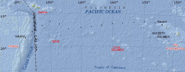
Our passage to Tonga - note our changing course to get the best winds.
Each line is 5 degrees, or about 300 nautical miles.
Our trip from Maupiti to the Vava'u Group of Tonga actually covered 1400 miles.
Destination Tonga Letters Related Pages |
Tonga Letters
 Our passage to Tonga - note our changing course to get the best winds. Each line is 5 degrees, or about 300 nautical miles. Our trip from Maupiti to the Vava'u Group of Tonga actually covered 1400 miles. |
|
Cruisers If you're planning to make the seemingly simple passage from Tonga to Fiji, check out our Passage Dangers page. It lists the locations of about 60 uncharted hazards between Tonga and Fiji, as well as a file you can download into MaxSea to automatically plot those hazards. This file also includes safe tracks through the Vava'u and Ha'apai Groups of Tonga. If you're planning to cruise western Fiji, here's another file you can download into MaxSea. It shows some safe tracks through the Mamanuca and Yasawa Islands, as well as additional island and navigational data. When you download either MaxSea User Data file, save it in your MaxSea folder (usually \Program Files\MaxSea or \Program Files\I&M\MaxSea). In MaxSea, click File, Open..., and in the dialog box that appears select User Data as the file type (near the bottom). Select the file you downloaded and the new data should appear. You can modify the data using MaxSea if you want. Selecting File, Close, will remove the displayed data without affecting the chart underneath. |
In many ways, our passage from Maupiti in the Society Islands of French Polynesia to the Vava'u group of Tonga was our most difficult passage to date. It wasn't as rough as our passage from Curacao to Panama, and it wasn't as long as our passage from the Galapagos to the Marquesas, but I still rate it as the most difficult. We started out by being blown out of Maupiti by "reinforced trades," catching some pretty violent squalls. At one point the anemometer was reading 46 knots of apparent wind (from dead behind us) and we were making a consistent 9 knots through the water, even with 3 reefs in the main and only a scrap of jib to push us along. After 4 days of this, the GPS projected that, if we kept our current (10 knot) speed, we'd be in Tonga in another 4 days. But then a low pressure area formed up west of us. It moved SE, as they usually do, but the clockwise winds surrounding it countered the trades, sucking up all our wind and leaving us becalmed.
Although the great-circle route is "only" 1,250 nautical miles from Maupiti to Vava'u, we sailed some 1,400 miles to get there. At some points, we actually found ourselves beating to get west, an almost unheard-of situation in these trades.
When the winds finally filled in again after the low passed south of us, some fronts (troughs, shear-lines, whatever - the weather reports never seemed to agree) meant that our last few days were beset with constant sail changes, as the winds shifted strength and direction constantly. I think that our last day the wind clocked completely around us - twice! It seemed like we were constantly having to adjust our sails. Were we ever glad to get the anchor down on May 19, 2004, the day before our 25th wedding anniversary.
As always, these newsletters are what we emailed out while we were actually out there, except that now they're illustrated. They represent our up-to-the-moment thoughts and feelings. While Jon wrote most of them, we all contributed, even Arthur.
Enjoy!
| May 2004 |
South Latitude |
West Longitude |
Day's Run |
Miles to go |
Wind Speed & Dir |
Comments |
| Wed 5 | 16° 27' | 152° 15' | 0 | 1,248 | 8-17@140° | Start in Maupiti |
| Thu 6 | 16° 19' | 154° 38' | 145 | 1,114 | 12-20@165° | Nice sailing |
| Fri 7 | 16° 38' | 157° 28' | 166 | 950 | 20-35@165° | 25kt winds, surfing |
| Sat 8 | 16° 41' | 161° 01' | 145 | 805 | 20-55@165° | 55kt squalls in am, 30kts all day |
| Sun 9 | 17° 22' | 162° 40' | 160 | 647 | 5-15@150° | Sunny, light winds |
| Mon 10 | 17° 18' | 164° 16' | 95 | 557 | 5-10@60-120° | Sunny, hot, & light |
| Tue 11 | 17° 10' | 164° 36' | 33 | 539 | 4-7@60° | Sunny, hot, FLAT |
| Wed 12 | 16° 44' | 165° 42' | 56 | 483 | 5-12@60-170° | Sunny, hot, very light winds |
| Thu 13 | 16° 20' | 166° 54' | 80 | 424 | 5-10@135° | Beautiful spinnaker run |
| Fri 14 | 16° 11' | 168° 00' | 66 | 368 | 4-12@80-120° | Green-flash sunrise! |
| Sat 15 | 16° 12' | 169° 55' | 130 | 269 | 4-24@variable | Squall dodging & wind shifts |
| Sun 16 | 17° 00' | 171° 12' | 89 | 182 | 0-18@variable | Flat calm, motor-sailing |
| Tue 18 | 17° 54' | 172° 44' | 105 | 78 | 8-18@variable | Trying to slow down! |
| Wed 19 | 18° 40' | 173° 54' | 100 | 0 | 5-25@NE | 1,400 miles total run |
Top Level: Home | Destinations | Cruising Info | Underwater | Boat Guests | Ocelot | Sue | Jon | Amanda | Chris | Site Map | Make a Comment
|
If our information is useful, you can help by making a donation |
Copyright © 2000‑ Contact: Jon and Sue Hacking -- HackingFamily.com, svOcelot.com. All rights reserved.