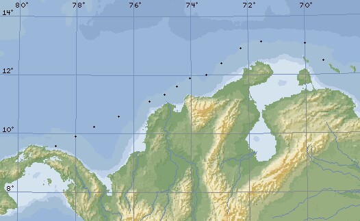
Our actual GPS positions from Curacao to the San Blas
Destination Panama Letters Related Pages Panama Passage |
Panama Letters
 Our actual GPS positions from Curacao to the San Blas |
Our passage to Panama started in Curacao and culminated in our arrival in the San Blas islands just east of the Panama Canal. Map scale is 120 miles (about 200km) per division.
 The beautiful outer reef of the San Blas islands |
This was our first multi-day passage in Ocelot, and it was something of a trial by fire (or perhaps by water). This trip was extremely rough, as February sees some very strong winds over the top of Columbia. We had heavy weather here when we made this crossing in 1988, and it doesn't seem to have changed much.
You can also read our individual impressions of our Panama passage in our Destinations section, but these newsletters were sent as emails from the boat while we were actually on passage, so they're our up to the moment impressions. And now we've even got photos attached.
Enjoy!
Top Level: Home | Destinations | Cruising Info | Underwater | Boat Guests | Ocelot | Sue | Jon | Amanda | Chris | Site Map | Make a Comment
|
If our information is useful, you can help by making a donation |
Copyright © 2000‑ Contact: Jon and Sue Hacking -- HackingFamily.com, svOcelot.com. All rights reserved.