
Swimming with whale-sharks at San Antonio
|
Cruising Info Pacific Cruising Info Related Pages SE Asia Flora & Fauna |
Cruising Philippines
This page is a departure from our normal format, in that it has no thumbnail photos, but shows only the large versions of all photos, including satellite shots of our anchorages and approaches. This requires more scrolling, but means that you don't have to click on the thumbnails to see larger versions. It also makes it easy to store a local copy of this page to your hard drive, to reference even when you're offline. On most browsers, simply right-click on the text and select Save as... In Internet Explorer, click the gear icon in the upper right, select File, and Save as... This should save the entire page, with all internal links and photos preserved. Double-clicking on the saved file should bring the full page up in your browser. Enjoy!
Why Cruise the Philippines? With over 6,000 islands, clear water, minimal pollution, great snorkeling and diving, plus tropical white sand beaches, this place is a Pacific cruising paradise. Like the rest of the western tropical North Pacific, it does get hit by typhoons. It's quite populous, and has been largely fished out. To counter that, the Filipino people are friendly, courteous, and fun. And most speak English, the country's second official language.
|
Swimming with whale-sharks at San Antonio |
Our Story: After returning to Indonesia from almost a year in PNG and the Solomon Islands, we decided to head north into the Philippines to buy new solar panels and see what the "big city" of Davao had to offer. We didn't know if we would stay a few months or more, so we took it one week at a time. We soon realized that we could traverse the entire country from Davao, up to the Visayas, across to Palawan and then jump off for Borneo to find a good Malaysian marina to leave Ocelot in while we took a multi‑month sojourn to the States and beyond. We enjoyed our time in Samal (the marina near Davao), the convenience of shopping, the good prices of things (like solar panels) and the camaraderie. In January 2020 we found one of the last calm weather windows and headed north up the east coast of Mindanao. This 200nm journey can be rough, heading against both wind and current in the winter. But we were lucky with super‑light winds (yes, we had to motor a lot) and we found a counter‑current in close to shore. We spent February exploring the Visayas with family visitors who left from beautiful Coron, north of Palawan. In early March 2020 we were all ready to sail south to Puerto Princesa to clear for Malaysia when the COVID‑19 pandemic hit. We got as far as El Nido and were quarantined on the boat for 2 weeks before being able to participate in life under Enhanced Community Quarantine in Corong-Corong and El Nido municipalities. That story is on‑going. The country graciously suspended all visa extension requirements, and we have been made to feel part of the community as we all locked down.
What you'll find here: This page provides information on Officialdom, Safety, Weather, Money, Provisioning, International Shipments, Fuel, Phones and Internet, Charts, and Downloadable Tracks.
Our Anchorages are below that, divided up into: SE (Mindanao), Central (Visayas), Mindoro, Busuanga, West Palawan and East Palawan. We now detail over 100 anchorages that we have personally been to, providing lat/lons, depths, bottoms, cell signals, approach issues, things to do, photos, and satellite images showing our entry and exit tracks as well as any nearby reefs or obstructions.
 Lovely deserted long sandy beach anchorages |
Officialdom: No visa is required ahead of time. On arrival and clearance with Immigration, cruisers receive a 30 day visa which must be extended every 60 days for up to 3 years, for about US$ 1/day/couple. Extensions usually take about 3 days, or you can pay extra for express (same day) service. Manila and Cebu can give 6 month extensions, but as of 2022, all other immigration offices are limited to only 2 month extensions. A $50 official ID card must be purchased every year, but they can take several weeks to arrive, so actually receiving them can be a problem for cruisers on the move. There are agents who can do extensions for you for about twice the cost of doing them yourself, but they need to hold your passport, which isn't strictly legal for many passports (we don't own our passports - they're officially the property of the government that issued them, and they're not supposed to leave our control). Clearance with the Customs office requires the normal last port clearance, boat papers, and crew list. As of 2022, you also need proof of Covid vaccination. We cleared in at Davao, with the boat in the Holiday Ocean View (HOV) Marina at the north end of Samal Island, and it was efficient and painless.
Recently, in Puerto Princesa, some cruisers have reported that Customs is asking for $50‑$100. While we've rarely experienced corruption in the Philippines, they won't issue a receipt for this, and it's not mentioned on the Customs website. This is always a ticklish situation, as it's their country, but several cruisers have pushed back on these fees and not had to pay them. We recommend ONLY paying fees that come with an official receipt, not just a stationary‑store receipt. Not only is this cheaper for you, but it makes it easier for other cruisers behind you. And ultimately, reducing corruption improves the country as a whole.
Safety: The Philippines gets a lot of bad press about the Abu Sayyaf Group (ASG), a terrorist organization based in the islands SW of Mindanao. The most infamous incident was the kidnapping of 4 cruisers from the HOV Marina in 2015, eventually resulting in the murder of the 2 Canadians. This was a huge slap in the face to President Duterte, who was Mayor of Davao for many years, so he stepped up security in the Davao area (and especially at the marina, which is probably one of the most secure places to be in the Philippines) and went after the ASG with a vengeance. Unfortunately, while they've been knocked back, it's very hard to completely eradicate terrorist groups, so it's very unwise to sail anywhere near the SW corner of Mindanao or the south Sulu Sea. Boats rounding Malaysia's Borneo will be aware of the Malaysian organized Passage to the East Rally escort by ESSCOM military forces due to the activity of ASG in that area. Isolated terrorist events have taken place in the central Visayas, but getting in the way of one of them is now very rare. Boats are now cruising through those areas continuously. Elsewhere in the Philippines, the people are welcoming and respectful of private property. We have heard of no boardings or petty theft from boats, nor theft of dinghies. The Philippine Coast Guard patrols most of the waters and our dealings with them have been courteous and professional, leaving us feeling welcome and secure.
 Rivers to explore with friendly locals |
Weather: Philippine winds are influenced by the monsoons. The NE Pacific trade‑winds, called the Amihan, are prevalent from about December through April. November and May are shoulder months with variable winds, and the SW monsoon, called the Habagat, blows from about June through October. Typhoons do cross the Philippines so one must stay vigilant. Generally, Davao, in southern Mindanao is too far south for typhoon activity. Central Visayas and northern Palawan (El Nido and Coron) are sometimes hit with late season storms in November and December. We were hit with typhoon Rai/Odette (the Philippines likes to apply their own names to storms) in Palawan, just south of El Nido, in December 2021, only our second cyclonic storm in over 25 years of cruising. We use Windy.com, checking both the GFS and ECMWF weather models (which often differ substantially) and if trouble is brewing we'll watch Robert Speta for a better analysis.
Remember, here in the northern hemisphere, cyclonic storms (typhoons) rotate counter‑clockwise. If this is hard to visualize, put a small cup upside down on a chart, and push it along the forecast track of the storm while rotating the cup CCW. The edges of the cup will show the wind directions.
Money: In 2022, there were just over 50 Philippine Pesos to the US dollar, which made conversion pretty easy. Simply double the peso amount and knock off 2 digits to get US dollars. Bills come in denominations of 20, 50, 100, 500, and 1,000 pesos. The money all changed in 2010, so make sure you don't get stuck with an old bill, as they're worthless now. ATMs are everywhere, but they all charge P250 (US$5) per transaction, so you want to withdraw as much as possible. BPI (Bank of the Philippine Islands) lets you take out P20,000 ($400) but almost all other banks only let you take out P10,000 ($200). One exception is HSBC in Davao, near G‑Mall, which apparently gives up to P40,000 ($800) with no fee, but there are very few of them so they're hard to find.
 Stunning scenery near El Nido, Palawan |
Provisioning: There is no doubt that the best selection of food stuffs will be found in the 3 major cities: Manila, Cebu and Davao. We didn't get to Manila, but in Davao City there are big malls with everything you could want. SM Lanang (the closet mall to the ferry from Samal Island) is well stocked and has shops like ACE Hardware and many other up‑scale places. Abreeza Mall is also good (groceries on the bottom floor as usual), and the Costco‑like S&R membership store where things are imported from Australia and North America. The stock turns over fast, so if you see what you want, buy it. It may not be there in a couple of weeks. They sell liquor and wines, but nothing Philippine-made. For cheap, local Tanduay Rum, hit the liquor stores in the other malls, or even the convenience stores over on Samal. Word is that the fresh market in Chinatown, Davao, has the best prices, but it may help to have a local friend do the shopping. We bought all our fresh fruits and vegetables in Babak, the village near the marina. Many big supermarkets (in the malls) have an "imported" aisle where you'll find tortillas, pickles, wasabi, etc.
 Wonderful snorkeling and diving |
In Cebu we shopped at Robinson mall right by the Yacht Club, which was adequate but lacking things like wraps (tortillas) and some other western food. We didn't get over to Cebu proper where the mall supermarkets are at least as well provisioned as in Davao. You can get a taxi or jeepney to go south to the fresh market.
In Puerto Princesa, the Robinson mall is only a 25 minute walk from the YC (we walk everywhere, for the exercise) and also houses the tiny Immigration office on the 2nd floor. There's a slightly more upscale SM mall about 45 minutes away in town, but we didn't like the grocery store as much. Just next to SM is the open market, as well as Ric, a superb computer repair guy.
Both Coron and El Nido, despite being major tourist areas, had very poor shopping when we were there, although a new department store (with groceries) has recently opened up there. The largest stores were about the size of a 7‑Eleven. The two main stores are Inggo Sari Sari in El Nido (closed Sat/Sun) and Mak in Corong Corong. Now that the pandemic is ending, specialty stores are opening, and some of them carry imported items, but costs are high. The items we missed most were: cheese, yogurt and good powered milk (with no additives or sugar). Cheese can be found in Le Nido at La Tienda, a deli across from the El Nido Bakery. Their stock varies from week to week, and despite the very high prices of $10/pound, they do carry mild cheddar, mozzarella, cream cheese, and other hard cheeses. With the lack of good powdered milk, we sometimes bought UHT milk or UHT yogurt. All grocery prices in El Nido (and the market in Corong Corong) are the highest we've seen in the Philippines, presumably because most things have to come from Puerto Princesa (a 5 hour drive) and they're used to catering to tourists. But the public market in Corong Corong was quite good, and we bought most of our fruits, vegetables, and pork there. Frozen chickens are available in El Nido, on the main road, next to a laundry. We never found good beef.
Somewhat strangely, several folks we know buy their specialty items on Lazada, which is sort of the local version of Amazon. They'll deliver to any door you specify, and most items can be bought on a Cash‑On‑Delivery (COD) basis. If you get friendly with a store or business, you can leave money with them to pay when it arrives. We did this with the Abanico YC in Puerto Princesa, Palawan.
 Magnificent anchorage at Corong Corong |
International Shipments: Somewhat surprisingly, the Philippines does not seem to respect "In Transit for Foreign Yacht" on packages, and just about everything will get held up in Manila as it goes through Customs. Several boats have had to travel to Manila personally to (try to) recover their packages shipped in from overseas via DHL or FedEx. Clearly, this is not a good option, although DHL seems to work better than FedEx.
However, there are other options. ShippingCart.com has locations in Hayward, California, Australia, Japan, Korea, and in England. You register with them and they give you an account number. When you have things shipped to them (with your account number in the address), they will aggregate them and then forward them on to whatever address you specify in either the Philippines or in Malaysia, and somehow the packages don't go through Customs! Note that there are restrictions on what you can ship, and they will open all packages and photograph the contents, both to verify them and to show you what has arrived. In the Philippines, they work with the LBC courier network, which has offices all over the country, and they can deliver a package to your door. Air freight prices are about US$ 7/lb plus a $12 handling fee, or you can ship by boat, which is slower but much cheaper ($2/lb). In normal times, packages take about 10 days to arrive.
Another option is Johnny Air, with offices in NY, San Francisco, and Los Angeles. They claim to ship in 7‑10 working days, but they only ship to their own offices in Manila, Davao or Cebu.
While we were in Palawan, we had LiFePO4 batteries shipped to us from China. To get the batteries to us and through Manila customs, we used the services of Import Anything (+63.917.638.4274). For about US$100, they got 8 270Ah LiFePO4 cells, with attachment hardware, from China to Manila and through customs. Then, for another $45, they gave the cargo to a freight forwarder they use to ship them on to us. They'll ship just about any cargo, of course. They insist that the boxes be unmarked, and then they send shipping labels via email, and give you an address of where to ship stuff to in China, and they take care of it from there. Once the cargo arrives and they process it through Manila Customs, they tell you how much to deposit into their bank account, so it's a COD sort of deal. All pretty simple, and it has worked well for several other cruising friends as well.
 Some pretty wild fishing boats |
Fuel: Diesel is readily available and seems to be of good quality (clear, with a slight greenish tinge). But, at just under US$1.50/liter (in 2022) in the population centers, and more in the outer areas, it's expensive relative to neighboring Malaysia and Indonesia. Prices don't seem to be regulated, so stations can charge what they like, and there are many different companies selling fuel. There's not enough marine traffic to warrant many diesel docks, so we hire a vehicle to take our jugs to a station.
 Colorful bouquets of tunicates |
Propane: Like many SE Asian countries, small shops in the Philippines prefer to simply swap tanks, but that requires that you buy a local tank and a regulator for it. This is the route that we've used, paying about $30 deposit on a tank and swapping it when necessary. We got a Petron tank, as they're available all over. In theory, you can get your deposit back when you return your tank, but we haven't tested this yet.
The local fittings look very much like the US/Oz/NZ (reverse thread) and the SE Asian (Malaysia, Indonesia) snap‑on fittings, but the Philippine variants are slightly smaller than (and therefore incompatible with) the foreign fittings. A bit frustrating. As far as we can tell, the smaller fittings are unique to the Philippines.
We came upon an interesting opportunity: ECGas (in Davao, +63‑932‑122‑5884) sells fiberglass tanks (made in Germany) for P5,700 (US$114) filled and with a regulator, which brings the price of the tank itself down to about US$ 85. The tanks are clear enough that you can see the level of propane inside, and, of course, they don't rust & they're wonderfully light. The tanks are slightly taller than our steel tanks, but they're the same diameter, so they fit in our same holders. They hold 24 lb (11Kg) of LPG, so they should last longer than our old 20 lb (9Kg) steel tanks. ECGas has several filling stations sprinkled around the Philippines (their website has a map of locations), but none in Palawan (or Busuanga or even Mindoro) as of 2022.
Unfortunately, they only sell them with a custom snap‑on fitting, which can't easily be filled by decanting as it doesn't have a bleed‑screw. This fitting looks a lot like the Malay/Indo fittings, but it's slightly larger, making it totally incompatible. However, the valve‑threads into the tanks are the same size and thread as most propane tanks worldwide, so the valves can be changed easily. Our old steel tanks were starting to rust (again) so we removed their US/Oz/NZ fittings and had Palawan Industrial Gasses (in PPC) put them in our empty fiberglass tanks, replacing the original snap‑on fittings. Any professional gas company should be able to do this. Our US/Oz/NZ reverse‑thread fittings aren't used much in the Philippines, but enough cruisers use such fittings that a good gas shop should have adaptors and can fill them by decanting from one of their tanks. Or you can fill them yourself by decanting if you can find a fitting for a local tank that doesn't have an integral regulator, but they're hard to find.
To decant from a full LPG bottle to an empty, it's handy to have a short length of rope, a long, flat screwdriver, a wrench for your gas fitting, a scale, a bit of ice and perhaps a rag in addition to your decanting setup. Having someone who's done it before is comforting, but not strictly necessary. Turn the full local bottle upside down and hoist it up as high as your decanting hose allows (in the sun if possible) with the rope and secure it. Connect your decanting hose to the empty tank. It's important to weigh the empty tank, so you know how much you've put into it. Extinguish all cigarettes and work in a well ventilated area away from any flames, sparks or motors. Open the valve on the empty tank first, then connect the local fitting to the (upside‑down) full bottle, which should start the liquid propane flowing. The expanding and compressing gas of the decanting process will tend to make the full bottle cooler (decreasing its pressure) and the empty bottle warmer (increasing its pressure) which is the opposite of what you want. Hanging the full bottle in the sun will help keep it warm, and putting a wet rag and some ice around the top of the tank being filled will reduce its pressure and help the process go faster, but neither are necessary. Also, some of the liquid will turn to gas in the tank being filled, and venting this gas at intervals will also help things go faster (there's usually a vent‑screw on the side of the US/Oz/NZ fill‑valve). Weigh the tank being filled every few minutes to track progress. We've found a 20 lb (9kg) tank usually takes about 20 minutes to fill this way (about 1 lb/min). When the tank is full, quickly disconnect the upper regulator and close the valve on the tank being filled. Be careful removing the fill‑hose, as it may still have some liquid propane in it. Voila!
 Stunning sunsets off Palawan |
Phones and Internet: There are 2 major companies providing cell services in the Philippines: Globe and Smart. Each offers their own deals and have their own apps, of course. Most areas are covered by both carriers, and neither is significantly dominant, but sometimes one is better than the other, and we try to note that in our anchorage descriptions. We bought a SIM for each, and swapped between them depending on which had the best signal for where we were anchored. Calls and texts across carriers cost more than within your carrier, but when you're calling someone, it's difficult to know which system they're on. In 2020, both were offering a similar deal of 800MB/day for a month (up to 24GB max) for P1,000 ($20), which seemed like the best day to day phone deal. Once you run through your allowance, they throttle throughput until it's unusable. Sometimes they send a text to say you've gone over your limit, but not always. In 2021, Smart started offering unlimited data deals for P600 ($12) for a month, which is a fabulous deal. Obviously, things are changing all the time. Coverage generally seemed pretty good.
If you're going to be in the Philippines for long, then you might consider investing in a MiFi device. It's basically a WiFi router with a SIM and Phone data system for the internet uplink. It provides much better speeds than we were able to get by tethering our phone. In 2022, the Globe‑at‑Home device was P1,000 ($20). Several data plans were available, the best (for us) being P1,000 ($20) for 70GB that lasts a month. The device is powered directly from 12v, which saves running an inverter, and it uses a very common power plug. Even better, in 2021 we bought a Smart‑Bro, which cost only P500 ($10), will let you have unlimited data for only P600 ($12) per month, and charges from a USB. It's tiny but has a large battery, so it can be hoisted up to the masthead to sniff out weak signals if/when you're in areas with weak coverage. Highly recommended.
And then there's Starlink, from SpaceX. Starlink deserves a page all its own, but things are changing so quickly that it would soon be out of date. It uses a series of Low Earth Orbit (LEO) satellites to provide low‑latency, high‑speed internet data to anyone, almost anywhere around the world (China, Russia, Venezuela, Cuba, Iran, Afghanistan, Syria, & Belarus are currently excluded). The Philippines was the first SE Asian country to sign an agreement with SpaceX, so the system is just getting started here as of this writing (June 2022). The user‑terminal is a flat‑faced phased array antenna, that tracks the satellites with its electronically steered beam, attached to a WiFi router. Prices in the US are currently $110‑135/month for unlimited data at about 100Mb/sec, but it's lower in other countries. This may change when the satellite‑to‑satellite laser‑mesh goes active (later in 2022?), allowing true worldwide usage (the poles are expected to get coverage in 2023). This price is about 10x what we pay for our Smart data, but it's also about 10x faster than the LTE speeds we get in most of the Philippines. The system also consumes about 50W (4A@12v) which is significant for many boats. Certainly something to think about...
 Philippine reefs really want good satellite imagery |
Charts: Like all of SE Asia, the navigational charts for the Philippines are terrible - either displaced or low
resolution or both. DO NOT TRUST YOUR CHARTS! We make our charts from Google Earth (GE), ArcGIS,
and Bing satellite imagery, as well as Navionics and CMap, usually using SAS Planet. You can see how at our
Making mbTiles How‑To page. The satellite imagery is extremely accurate
(maximum errors on the order of 10' or 3m) and can be very high resolution, as we make them at only
2000m elevation (for GE) or zoom level 18 (SAS) to get all the detail they have to offer. It's very comforting to know your charts are exactly
correct. Making your own charts (KAPs or
mbTiles) is very time and bandwidth consuming (we have a HUGE amount of time and
effort invested in ours) but the tools are all free and we show you how on our
Making mbTiles page.
Or, we've posted our own KAPs for cruisers to download.
These KAPs are huge, and we have to pay extra to provide this service, so we ask for a small donation (or make
a large donation ![]() ). They cover the
entire coastlines of most cruising areas from Micronesia and the Solomons in the east to the Maldives and Chagos. KAPs are a
MapMedia format which most computer‑based navigation programs can display. We typically use the excellent
open‑source navigation program
OpenCPN, a free download, to display our KAPs and mbTiles, and we use a
COM‑port splitter to feed our GPS signal to both OpenCPN and SAS.
Displaying both programs side‑by‑side on a wide‑screen display gives the best of both worlds when dodging between
coral‑heads. We've also posted our sailing tracks through the Philippines below, along with chart annotations and possible
additional anchorages.
). They cover the
entire coastlines of most cruising areas from Micronesia and the Solomons in the east to the Maldives and Chagos. KAPs are a
MapMedia format which most computer‑based navigation programs can display. We typically use the excellent
open‑source navigation program
OpenCPN, a free download, to display our KAPs and mbTiles, and we use a
COM‑port splitter to feed our GPS signal to both OpenCPN and SAS.
Displaying both programs side‑by‑side on a wide‑screen display gives the best of both worlds when dodging between
coral‑heads. We've also posted our sailing tracks through the Philippines below, along with chart annotations and possible
additional anchorages.
Note that OpenCPN now allows one to adjust CM93 charts to position them more accurately. This also positions depth readings more accurately:
 Impressive coastal mountains of Mindanao |
Cruisers: We are now publishing Downloadable Track Files in OpenCPN (.gpx) format and in MaxSea (.ptf) format (not all tracks are available in all formats yet - we're still working on it and they take time). You can download the track files either by clicking on the links in the tables below, or by clicking on the track in the Google Map below the table. The MaxSea files are in native format but the OpenCPN files are zipped so they download faster, and they need unzipping after they've been downloaded (which most operating systems do natively). If 2 files are shown, the smaller one has been edited to remove redundant points from straight tracks. This improves the speed of the download as well as performance once the file is loaded. Sometimes MaxSea Track files are separated from the Mark (chart notations) files. Download instructions are provided if you need them.
These files are provided free and we are actively soliciting cruisers to send us your track files so we can post them for others to download. If you would like to to participate, please email us your track files (as attachments to our HackingFamily account, not our Winlink acct) along with your boat name and draft. If you include your website and boat details, we'll link back to you from our Cruising Links page.
Disclaimer: While we always try to provide useful information, we can take no responsibility for its accuracy or usefulness. Prudent mariners will always navigate using all means at their disposal, and will not rely solely on electronic navigation.
Philippines Tracks
| Boat | Draft | Year | Comments | OpenCPN |
| Ocelot | 4.6' (1.4m) | 2022 | Davao to Palawan plus Mindoro | 225 KB |
| Ocelot | 4.6' (1.4m) | 2022 | Anchorages only (included in above) | 54 KB |
| Soggy Paws | 4.6 (1.4m) | 2021 | Davao to Palawan & back (x2) | 473 KB |
 Tracks through the Philippines, Davao (lower right) to Palawan, Ocelot in green, Soggy Paws in red |
South-East Philippine (Mindanao) Anchorages
The table below, with the more in‑depth comments below that, lists all of the anchorages we visited on our way up the coast of Mindanao. The anchorage links go to the in‑depth comments below. We've now added satellite shots of each anchorage, with our track in and out (our anchorage is usually pretty obvious from the track). Our tracks are in Green, but other boat's (red) tracks are sometimes visible. These are much better than mud maps, and they're all oriented North up. Depths are in feet, distances are in nautical miles, latitudes are all north, and longitudes are all east. As always, if you have questions or comments, please contact us - we'd love to hear from you!
| Month | Anchorage | Area | North Latitude |
East Longitude |
Depth feet |
Cell Globe Smart |
Comments | |
| Jan | Lavigan Inlet | Davao Bay | 6º18.16 | 126º11.21 | 32' mud | No | No | Lots of fishing boats |
| Nov | Baksal Cove | Davao Bay | 6º40.71 | 126º05.23 | 51' mud | 3G | 3G | Exposed to the N and W |
| Jan | HOV Marina | Davao | 7º11.89 | 125º42.62 | Marina | 4G | 3G | Too nice, like Hotel California |
| Jan | Lucatan | E Mindanao | 7º00.11 | 126º25.05 | 40' mud | No | 3G | Headman Ri came to visit |
| Jan | Baganga Bay | E Mindanao | 7º36.40 | 126º33.99 | 32' mud | 3G | 3G | Some swell comes in |
| Jan | Barcelona | E Mindanao | 8º09.58 | 126º26.59 | 18' mud | Yes | Yes | Protected from NE, no swell |
| Jan | Caguait Harbor | E Mindanao | 8º55.66 | 126º17.92 | 18' mud | 3G | 3G | Nice offshore breeze at night |
| Jan | General Island | NE Mindanao | 9º24.80 | 126º00.14 | 63' sand | 3G | 4G | Very protected, but small |
| Jan | Kantiasay | NE Mindanao | 9º51.02 | 125º35.07 | 35' sand | 4G | 3G | Protected in N winds |
| Jan | Mabua (Surigao) | NE Mindanao | 9º47.83 | 125º26.30 | 20' mud | 4G | 4G | Swell can wrap into bay |
| Is this useful? Buy us a beer! |
|
Lavigan Inlet, Davao Bay, 6º18.16'N 126º11.21'E, 32' mud, no cell signal We came into Lavington Inlet on a moonless night, which we wouldn't recommend, after running over a huge
FAD in the dark (which we also don't recommend
Lavigan is one of the closest anchorages to Cape St. Agustin, and offers good protection from all points except the west. It's a good jumping‑off point for rounding the Cape and starting up the east coast of Mindanao, but it's 63nm to HOV Marina, so a long sail.
Return to: Top, SE (Mindanao), Central (Visayas), Mindoro, Busuanga, West Palawan or East Palawan. |
|
Baksal Cove, Davao Bay, 6º40.71'N 126º05.23'E, 51' mud, 3G cell signal Baksal Cove is one of about 4 anchorages along the eastern arm of Davao Bay that provides protection from the southerly winds that we had in November. There's only 1 small reef to avoid when approaching from the west, but to the NW are a sprinkled handful of reefs that extend for 6nm that need to be avoided. Our winds were light, so we anchored fairly far from shore, but in stronger winds there's probably better protection closer to shore and/or a bit further east, although there are lots of fishing boats to the east.
Otherwise, the anchorage is unremarkable. It's only 40nm to Holiday Ocean View Marina at the north end of Samal, so an easy day sail in either direction. Cell towers are visible from the anchorage, so there's good internet.
Return to: Top, SE (Mindanao), Central (Visayas), Mindoro, Busuanga, West Palawan or East Palawan. |
|
Holiday Ocean View (HOV) Marina, Davao, entrance at 7º11.89'N 125º42.62'E, good cell signal (& free WiFi at the clubhouse) There are at least 3 barriers to prevent unauthorized boats from entering the marina, so make sure to let the office know when you plan to arrive, as it can take several minutes for them to move the barriers. As of early 2020, they wanted boats to only use the right (eastern) set of slips. 220v 60Hz(!) power is available, with generator backup. Dock water is free, RO drinking water is $0.80/jug (20L).
In the satellite photo, the 3 big white buildings are the "condo‑tel" (mostly unoccupied) and to the right the black‑roofed marina clubhouse, hard‑stand, workshop, and haul‑out ramp. To the north of the clubhouse is now a small but pleasant open‑air restaurant. Up the steep hill is an area for housing, but there wasn't much happening there in 2020. The road at the bottom is the main road around Samal, left going to Babak and the ferries to Davao. HOV Marina is a bit like Hotel California, in that it's so nice that it's difficult to leave. Cruisers organize potlucks, trips to local restaurants, singing nights, and exercise classes. The undeveloped property on the hill above the marina is part of the marina property and is a great place for walks and birding. A free shuttle runs to the ferries (and Babak, the local village) 3x/day, and another free shuttle takes people to the big Davao shopping malls and back every 2 weeks. Our 45' cat was charged $360/month, including electricity for our air‑conditioner. There's no charge for water, but the WiFi really only works at the clubhouse. Toilets and hot showers are in the clubhouse, along with laundry facilities, a TV and fridges with beer and sodas (honor system). Tata runs the workshop and can organize laborers for about $10/day. They can do wood, fiberglass, and some metalwork, including stainless steel welding. Unfortunately, the owner of the marina wants to turn the hard‑stand into more parking for the condo‑tel (which had very few patrons in 2020) so they're not allowing boats out for extended periods anymore, just for a quick bottom or repair job. In 2022 we heard rumors of this policy changing and the hardstand reopening, but we haven't been able to confirm this yet.
In 2015, the terrorist group Abu Sayef kidnapped 4 cruisers from the marina and eventually executed the 2 Canadians. But President Duterte was Mayor of Davao for many years, so it was a huge slap in his face, and he promptly improved security all over the area. Now a patrol boat lives in the marina, there are (very friendly) armed guards all over, a tower and guard post at the far corners of the breakwater, and no fewer than 3 floating barriers to entering the marina. While the satellite photo shows few boats there, it was taken shortly after the attack. Now more boats are there, and it feels very safe. Babak is the town on Samal between HOV and the ferries. There are several shops, but quality and prices will probably be better in Davao. The public market on the water is generally very good for fresh fruits, veggies, and pork. There are several vendors selling spit‑roasted chickens, which are excellent and less than $4. We used Santos (get one stuffed with lemon‑grass).
Davao is a fairly amazing city, and much bigger than any city we've been to in SE Asia for a long time. Luckily, Google Maps seems to know where everything is. There are several shopping malls, for those so inclined, as well as a bustling (if cramped) Chinatown. Taxis are all metered and air‑conditioned, and were our preferred mode of getting around. They start at $0.80 to get in, and a 30 minute ride (which is long) might cost $5. Jeepneys are much cheaper, but they stop much more often, aren't air‑conditioned, are usually very crowded, are difficult to see out of, and we didn't get around to figuring out where they went. Some Davao highlights:
Return to: Top, SE (Mindanao), Central (Visayas), Mindoro, Busuanga, West Palawan or East Palawan. |
| Is this useful? Buy us a beer! |
|
Lucatan, East Mindanao, 7º00.11'N 126º25.05'E, 40' mud, No Globe, 3G Smart Lucatan was the furthest north we could get once we rounded Cape San Agustin from Lavigan inlet, a 52nm day. There are no hazards to the approach. In the light NE winds we had at the time, it provided good protection and a quiet night. Looking at the satellite imagery, it's probably better to anchor about 80m to the east, up on the sand shelf, so the anchor isn't on such a slope.
We were a bit surprised to have the local headman, Ri (+63‑938‑853‑9708) come out to Ocelot (with an armed guard) to see what we were up to. After a gruff beginning, he realized we were no threat, and he became much more friendly, even offering to host us at his small home‑stay. He then contacted us several times as we continued up the coast and as we cruised the Philippine interior, tracking our progress and praying for our safety. There's a good Smart cell‑tower at the end of the point, but no Globe signal in early 2020. We had fairly strong (2.5 knot) southbound current against us just after rounding Cape San Agustin, but it soon turned into a positive counter‑current as we hugged the coast.
Return to: Top, SE (Mindanao), Central (Visayas), Mindoro, Busuanga, West Palawan or East Palawan. |
|
Baganga Bay, East Mindanao, 7º36.40'N 126º33.99'E, 32' mud, Good Globe & Smart Baganga Bay in one of a series of conveniently spaced anchorages along the east coast of Mindanao, just 44nm north of Lucatan. Unfortunately, it has a shallow reef smack in the center of the approach to the bay, and the reef from Lambajon Point extends south quite a ways (see satellite shot). You can go on either side of the central reef, but different charts have it positioned differently, so satellite imagery is best.
The town (Lambajon?) is actually quite big, with several fishing boats nestled at the north end of the bay, behind the dock. You can anchor just about anywhere along the eastern arm of the bay, but we chose to stay away from any potential shipping that might want to use the dock, so we anchored about in the middle but as far north as we could. Unfortunately, a swell sometimes works its way into the bay, and it can get uncomfortable if it catches you beam‑on. There was good cell coverage by both carriers.
Return to: Top, SE (Mindanao), Central (Visayas), Mindoro, Busuanga, West Palawan or East Palawan. |
|
Barcelona, East Mindanao, 8º09.58'N 126º26.59'E, 18' mud, good cell signal Barcelona is another conveniently located protected bay, 38nm north of Baganga Bay. There are no hazards getting in or out, but the reefs extend quite far south when heading north. Although the waves can wash over the protecting reefs, the bay itself is remarkably protected, without any swell when we were there. Anchor as far in as you can, to get the most protection. The bottom becomes more sandy the further you go in.
Like in most other anchorages in the Philippines, we were pretty much ignored by the local fishermen. This was a somewhat strange, but a relaxing change from the Indonesian "Hello Mistah!" that you get from passing children, or the quiet stares of villagers in the Solomons and parts of PNG.
Return to: Top, SE (Mindanao), Central (Visayas), Mindoro, Busuanga, West Palawan or East Palawan. |
|
Caguait Harbor, East Mindanao, 8º55.66'N 126º17.92'E, 18' mud, Good 3G cell signal Caguait Harbor is 53nm from Barcelona, so a relatively long day, but the other anchorages to the south all had issues. Bitogan Bay and Ayninian Island can both have strong currents. Caguait isn't as well protected from east sector winds, but it was relatively calm when we were there. A bit of swell came into the bay, but a lovely offshore breeze at night kept our stern to the swell and brought us cooler temperatures. There are no hazards when entering, but the bay shoals quickly if you try to go south. Also, there appeared to be small mooring lines sprinkled around the south side of the bay, possibly for tiny fishing boats, so we anchored more towards the middle of the bay. There were 2 big cell repeater stations on the hill to the north that we could just see from our anchorage, and another much smaller tower in the village. Staying in sight of those repeaters will probably give you a better cell signal.
There's a small village ashore, but we didn't go in and they didn't come out to say hello.
Return to: Top, SE (Mindanao), Central (Visayas), Mindoro, Busuanga, West Palawan or East Palawan. |
|
General Island, NE Mindanao, 9º24.80'N 126º00.14'E, 63' sand, Globe 3G, Smart 4G There are no real hazards when approaching General Island from the east, but to the west is a small island (with a reef around it) as well as a shallow reef, both of which show in the satellite view, and have to be avoided. The General Island bay is rather deep, so you really want to drop your anchor as close to the middle of the innermost bay as you can, as you'll swing quite close to the surrounding reefs.
There's a village at the head of the bay, with some nice looking guesthouses on the left (see photo below), and some shallower bays to the east. Exploring those bays by dinghy brought us to a small resort. The owners were friendly enough, but since there were no overnight guests at the time, they weren't prepared to give us a meal. Locals often use the picnic facilities at the resort, for which they're charged a small fee.
Return to: Top, SE (Mindanao), Central (Visayas), Mindoro, Busuanga, West Palawan or East Palawan. |
|
Kantiasay, Nonoc Island (south end of Dinagat), 9º51.02'N 125º35.07'E, 35' sand, 4G Globe, 3G Smart Kantiasay is actually the village on the right, and San Pedro (shown as Hamgad in CM93) is on the left. There are no approach hazards except a green float in the middle of the bay, but it's pretty deep until you get quite close, and the shallow areas usually have fish traps (or pens) on them. Favor the east side to take advantage of the big sand flat. We had strong NE winds that kept us off the shallows.
There's a 1/4nm long footbridge that joins the two villages, and also blocks boats from entering the big lagoon, but the bridge has a high spot where dinghies can get under if you want to explore. A local ferry (with outriggers!) leaves from San Pedro at 7am to go to Surigao, and returns about noon. There's a tiny cell‑tower in Kantiasay. Smart reported the stronger signal, but we got better performance from Globe. Although we were headed for Surigao, Kantiasay provided shelter in the NE winds before we returned to the coast of Mindanao and the west side of the peninsula that houses Surigao town.
Return to: Top, SE (Mindanao), Central (Visayas), Mindoro, Busuanga, West Palawan or East Palawan. |
|
Mabua (Surigao), NE Mindanao, 9º47.83'N 125º26.30'E, 20' mud, 4G Globe & Smart There are no hazards to approaching Mabua. Come as far into the bay as you can, and anchor as convenient. It's all shallow, gently sloping mud.
In the NE season, the entire coastline off Surigao is a lee shore, with no protection at all. Therefore, we decided to sail around the northern peninsula and anchor off Mabua, thinking we could take a bus or jeepney to Surigao. Several other boats have reported that this works well. There are no docks, but there are several small resorts along the beach who will apparently watch your dinghy. However, a swell can come around the point and down into the bay, making life uncomfortable. We moved our bridle around to our side, to keep us bow into the swell, but sometimes there wasn't enough wind to keep us pointed correctly. In the end, we gave up and continued NW without ever going ashore.
Return to: Top, SE (Mindanao), Central (Visayas), Mindoro, Busuanga, West Palawan or East Palawan. |
Mid-Philippine Visayas Anchorages
The table below, with the more in‑depth comments below that, lists all of the anchorages we visited on our way through the middle of the Philippines, primarily Leyte, Cebu, and Panay Islands. The anchorage links go to the in‑depth comments below. Our tracks are in Green, but other boat's (red) tracks are sometimes visible in the satellite shots. The satellite shots of our anchorages are all oriented North up. Depths are in feet, distances are in nautical miles, latitudes are all north, and longitudes are all east. As always, if you have questions or comments, please contact us - we'd love to hear from you!
| Month | Anchorage | Area | North Latitude |
East Longitude |
Depth feet |
Cell Globe Smart |
Comments | |
| Jan | Santa Paz | Panaon | 10º05.54 | 125º07.40 | 18' sand | Good | Good | Nice walking/birding ashore |
| Jan | San Antonio | Panaon | 9º57.65 | 125º14.20 | 40' mud | Good | Good | Swimming with whale‑sharks! |
| Jan | Maasin | Leyte | 10º07.66 | 124º50.04 | 28' sand | Good | Good | Nice public market and fuel |
| Jan | Hingotanan | Bohol | 10º14.54 | 124º28.70 | 42' rubble | Good | Good | Huge tidal reefs system |
| Jan | Mactan | Cebu | 10º19.65 | 123º58.30 | 27' mud | 4G | 4G | Good airport access |
| Feb | Port Carmen | Cebu | 10º34.07 | 124º01.83 | 15' mud | Good | Good | Protected, marinas nearby |
| Feb | Poro Island | Leyte | 10º37.65 | 124º24.20 | 30' rubble | Good | Good | Settled weather only |
| Feb | Palompon | Leyte | 11º02.70 | 124º22.85 | 30' mud | Good | Good | Excellent protection |
| Feb | Malapascua | Cebu | 11º19.77 | 124º06.57 | 28' sand | Good | Good | VERY touristy |
| Feb | Roxas | Panay | 11º36.13 | 122º42.66 | 20' mud | Good | Good | Very protected, shoals quickly |
| Feb | Port Batan | Panay | 11º35.80 | 122º28.72 | 30' mud | Good | Good | Protected, easy fuel |
| Feb | Caticlan | Panay | 11º55.40 | 121º56.73 | 26' mud | Good | Good | Good airport access (Borocay) |
| March | Talaba River | Sibuyan | 12º20.97 | 122º32.95 | 22' mud | 4G | 4G | NE season only |
| March | Banguid Bay | Romblon | 12º33.97 | 122º14.98 | 30' rubble | 4G | 4G | Protected, very nice |
| March | Mainit | Banton Is | 12º55.48 | 122º03.31 | 45' sand | 2G | None | NE season only |
| Is this useful? Buy us a beer! |
|
Santa Paz, Panaon, 10º05.54'N 125º07.40'E, 18' sand, Good Globe, Good Smart Santa Paz was a bit out of the way for us, but we had friends there we wanted to reconnect with. There are no real obstacles to entering, but the reef comes up pretty quickly, and the shallows extend out from shore by as much as 100m (330').
Our friend, Isabelle on s/v Manta, took a mooring a bit NW of us, very near a coral outcropping. So the next morning we did an easy dive around the reeflet where the coral was very healthy and sported many colorful tunicates and small fish. The town is small and the people very friendly when Isabelle and Sue when ashore for a walk. But our goal on Panaon was to hunt for the wild and elusive ... whale shark! (see below).
Return to: Top, SE (Mindanao), Central (Visayas), Mindoro, Busuanga, West Palawan or East Palawan. |
|
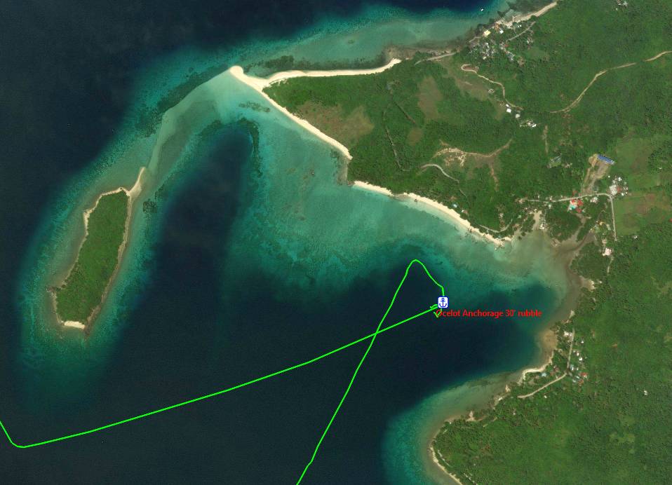
San Antonio, Panaon, 9º57.65'N 125º14.20'E, 40' mud, Good Globe, Good Smart San Antonio is on a fairly open bay that faces SSW, and is often referred to as Sonok Point. There are no hazards when approaching or leaving. There are actually 2 good anchorages just SE of town on small sand‑fans that you can see from satellite images. The anchorage just off the town has more coral and we don't recommend it.
At the southern tip of Panaon is a shallow bay where one can often see whale‑sharks, which was our mission when we were there with our friend Isabelle on s/v Manta. We went into town and asked for a whale‑shark guide, and were directed to a small shop where we signed in and paid our money. In 2020, we paid $4/person, plus $6 for a guide and $4 each for 2 spotters, which is about what we'd pay in Triton Bay. They arrived the next morning and we loaded 3 people into each of our dinghies, and we towed one of their spider‑boats. It's over 4nm to the southern bay, but each dinghy could plane so it went pretty quickly. Once there, we milled around the bay with several other small craft, with our spotters spotting as best they could. When someone shouted, we zoomed over and jumped in, leaving our spotter to look after the dinghy. The whale‑sharks are not fed, so they're always moving. They don't swim very fast, but it's a good workout to keep up with them as they cruise around the bay.
Return to: Top, SE (Mindanao), Central (Visayas), Mindoro, Busuanga, West Palawan or East Palawan. |
|
Maasin, Leyte, 10º07.66'N 124º50.04'E, 28' sand, Good Globe, Good Smart There are no hazards when approaching Maasin, and our anchorage is in a lovely sandy patch. You can anchor closer in, but then you get more rocks. There's another somewhat more protected bay about 4nm to the east (Ichon) and we saw some boats anchored there, but the town is much smaller, and we wanted to shop.
One problem with Maasin is where to put the dinghy. Going around the semicircular reef, you can approach the tiny sandy beach (middle of the photo) from the west. It's quite shallow, but you can pull your dinghy up on the beach there if you want. We ended up going due north from our anchorage to the near corner of the area with the white‑roofed building. The concrete wall and road are quite high there, but you can walk or wade on some rocks to get around the corner and up to road level, where you can tie your dinghy to some structures. Maasin has a nice public market, and friendly people. We took our fuel‑jugs ashore here and a tricycle took us to the fuel‑station and back, then the driver helped lower our jugs 7' (2m) into our dinghy with a rope.
Return to: Top, SE (Mindanao), Central (Visayas), Mindoro, Busuanga, West Palawan or East Palawan. |
|
Hingotanan, Bohol, 10º14.54'N 124º28.70'E, 42' rubble, Good Globe, Good Smart As you can see from the satellite photo, the reefs extend out for over 1/4nm from the islands, and you need to know where they are as you approach, so satellite imagery is useful. And it's almost essential for safe navigation inside the lagoon, as there are several reefs.
I think a better anchorage can be had either NE or SW of ours, as the bottom was smoother, so it's probably sand instead of the coral rubble we dropped onto. There's room for many boats to anchor. Both islands are essentially covered in village, but we didn't go ashore, and nobody came out to talk to us.
Return to: Top, SE (Mindanao), Central (Visayas), Mindoro, Busuanga, West Palawan or East Palawan. |
|
Mactan, Cebu, 10º19.65'N 123º58.30'E, 27' mud, 4G Globe, 4G Smart There are no real hazards when approaching, but the shallows extend NE of Mactan Island for a fair way. The rectangular area just west of the yacht club is a ferry landing, and the ferry comes several times a day. If you anchor too close, he'll honk at you.
The YC wants P200 ($4) per day to leave your dinghy on their dock, but it's the best game in town, as other places are more expensive. The YC has a restaurant (small red roof) and a small chandlery, & there's another chandlery (larger red roof) just to the east. Going out the guard gate and down to the corner brings you to Robinson's Mall, which is quite up‑scale, with a good grocery store. There's another big grocery store diagonally across the main road. The public market is a jeepney ride to the west, past the second bridge. There are other malls as well. We did not get into Cebu proper. This is a great anchorage if you have people flying in, as you can walk to the airport. Then you can negotiate with a jeepney (or taxi) for the trip back to the YC. And, of course, all of Cebu City is just across the bridges, if you need stuff for projects. Cebu's as big as Davao, so should have just as many resources available.
Return to: Top, SE (Mindanao), Central (Visayas), Mindoro, Busuanga, West Palawan or East Palawan. |
|
Port Carmen, Cebu, 10º34.07'N 124º01.83'E, 15' mud, Good Globe, Good Smart The approach to Port Carmen is tricky, as big ships are also using the narrow channels. There were floating buoys to mark the entrance, but not subsequent turns or passages, so satellite imagery is very useful. The common anchorage is to the south, in a small, shallow pond that can hold about 15 boats.
There are many ships being loaded with gravel (or something) just across from the southern anchorage. Unfortunately, the breeze often turns at night to come from shore, so the dust and grit of the loading operations gets all over the boat. You can anchor in the northern bay, and this puts you closer to the local town, but there have been (unverified) reports of thefts there. Further south (at the bottom of the photo) are some small marina‑ish things, with several (somewhat derelict) boats. But Zeke's is apparently not a bad place to work on your boat, and Jeepneys and taxis can get you into Cebu city for whatever you need. Some cruisers do their Cebu port clearances and visa renewal from here, since Cebu will grant you a 6 month visa extension (most Immigration offices only give you 2 months).
Return to: Top, SE (Mindanao), Central (Visayas), Mindoro, Busuanga, West Palawan or East Palawan. |
|
Poro Island, Leyte, 10º37.65'N 124º24.20'E, 30' rubble, Good Globe, Good Smart There are no hazards to avoid when approaching this anchorage, but it's not as good as it looks. We thought we'd be anchoring on sand, but it turned out to be coral rubble. Scrutinizing the satellite imagery, it looks like the anchorage in the next bay to the east, near 10º37.63'N 124º24.82'E, might offer a better bottom. We had some rain here, and something caused the wind to wrap around Poro and come from the east, which gave us a bumpy night. Not sure how common that is in the NE season.
By going around the docks we could load and unload passengers at the ramps that the ferries use, and perhaps we could have left the dinghy tied to the side of those ramps. We rented some scooters ashore and set out around the island, but the roads are pretty poor, so progress was slower than anticipated. The town itself is cute, and the people very friendly, so walking around town was fun. Our visiting family said the snorkeling was good, but we didn't go ourselves.
Return to: Top, SE (Mindanao), Central (Visayas), Mindoro, Busuanga, West Palawan or East Palawan. |
| Is this useful? Buy us a beer! |
|
Palompon, Leyte, 11º02.70'N 124º22.85'E, 30' mud, Good Globe, Good Smart There are no real hazards when approaching Palompon, but the reefs extend out quite far, and they're often covered by muddy water, so you can't see them well. Satellite imagery is a big help here. Proceed past town and anchor as convenient. The estuary is quite large.
There are some interesting wildlife viewing towers SW of the anchorage, and that whole area is a nature preserve. Unfortunately, the dock and walkways are falling into disrepair, so judge for yourself if they're safe enough. The tower itself is concrete, and quite strong. It gives some wonderful views, but the local cyclone damage hasn't been repaired since 2014. The estuary south of the anchorage is large and invites exploration by dinghy. The town looks large and vibrant, but we'd had a rather sleepless night at Poro Island, so we didn't go into Palompon town.
Return to: Top, SE (Mindanao), Central (Visayas), Mindoro, Busuanga, West Palawan or East Palawan. |
|
Malapascua, Cebu, 11º19.77'N 124º06.57'E, 28' sand, Good Globe, Good Smart There are no hazards when approaching Malapascua except for the extensive shallows to the south, but given Soggy Paws' track (red) you can probably sail over that if necessary. The best anchorage changes depending on the season. We were there in February, with NE winds, so we anchored in the SW.
Malapascua is quite a tourist island, with lots of diving opportunities. There's an interesting dock with car tires embedded in the concrete as bumpers. It makes a good place to tie the dinghy, but make sure it doesn't slip under the dock to get squashed by a rising tide, and leave room for the "spider" work‑boats to load and unload. Ashore there are lots of bars, restaurants, and resort accommodations to fit any pocketbook. There are a few tiny shops, but apparently most companies import their own needs, so very little is actually sold on the island. The people are friendly and we enjoyed walking around the south end of the island. The area is famous for dives with Thresher Sharks. The local dive shops will want to do this dive very early in the morning, but cruisers have reported that the sharks are actually around all day, so an early dive isn't really necessary.
Return to: Top, SE (Mindanao), Central (Visayas), Mindoro, Busuanga, West Palawan or East Palawan. |
Roxas, Panay, 11º36.13'N 122º42.66'E OR 11º36.00'N 122º42.38'E, 20' mud, Good Globe, Good Smart
There are no hazards approaching Roxas (pronounced Ro‑hass). You can even come in at night, as both sides of the entrance are marked with flashing lights. Note that the Philippines seems to use the US buoyage system (Red Right Returning, or Red Left Port). Ships use the dock to the north, so make sure you give them room to turn around.
Do not go further in than we did, or if you do, anchor further ENE, as that's where the channel is (Navionics charts are better positioned than CMap). If you look closely at the satellite image, you'll see a faint line extending in a curve from the lower breakwater up and to the right, just in front of where we anchored. That's a mud‑bank that dries at low tide.
 Roxas anchorage and approaches |
If you'd rather not deal with ships coming and going, and conditions are settled, you can easily anchor outside the breakwater. We anchored at 11º36.00'N 122º42.38'E in 23' of sticky mud when friends didn't want to anchor further north inside the breakwater. One advantage of the outside is that it avoids the wakes from the many fishing boats coming and going every morning and evening.
Roxas is an interesting place. Town is fairly far away, but is quite big and sports some big shopping malls with good grocery stores (the new SM should be open now) and nice restaurants. We pulled our dinghy up on the beach at the very top of the photo, outside the breakwater, but there were several places inside the breakwater, with ladders coming down to the water, that we could also have used. Tricycles are available around the dock area. There are lots of beach restaurants on the drive into town. Exploring up the river by dinghy is fun, as there's lots of aquaculture on the sides, but the channel winds around just past our anchorage.
 Anchor as far past the dock as you can |
Return to: Top, SE (Mindanao), Central (Visayas), Mindoro, Busuanga, West Palawan or East Palawan.
|
Port Batan, Panay, 11º35.80'N 122º28.72'E, 30' mud, Good Globe, Good Smart The entrance to Port Batan is over 20' (7m) deep, contrary to some postings. However, the channel is not well marked, it's quite long, and it can be difficult to see even with satellite imagery. It's probably best to follow our track, but you can also use these waypoints: 11º38.0 122º29.9, 11º36.6 122º29.8, 11º36.2 122º29.7, 11º35.5 122º29.4, then curl to the right and anchor behind the docks.
Port Batan is actually the town on the SE side of the bay. There are steps down into the water and some railings you can tie your dinghy to. There's a pretty good fruit and veg market about a 5 minute walk into town. There's also a fuel station near the steps, but the diesel is much cheaper on the other side, near the anchorage. Take your dinghy past the big docks and around to the small ferry landing (also steps into the water). The Petron station 200m down the road was closed when we were last there but might reopen. We hired a tricycle to carry our jugs & they should know where the best fuel is. This was shorter, easier, and cheaper than going all the way to Port Batan. The estuary system is huge, with lots of opportunities for dinghy exploration.
Return to: Top, SE (Mindanao), Central (Visayas), Mindoro, Busuanga, West Palawan or East Palawan. |
|
Caticlan, Panay, 11º55.40'N 121º56.73'E, 26' mud, Good Globe, Good Smart There are some rocks off the tip of Panay when arriving from the north or east, but they're easy to see and avoid. There's a tremendous amount of traffic going between Caticlan and Boracay Island to the NW, so anchor as far south as you can to avoid their wakes. Stay offshore until you can see the runway, and anchor on either side of it. It can shoal quickly, so you'll probably be fairly far from shore. The anchorage above is at the end of the lower green track‑line, our third anchorage attempt. We had 20 knot NE winds, but very little swell came into the anchorage.
Unfortunately, there's no good place to leave a dinghy except pulled up on the beach by the runway. There are lots of docks with steel steps leading down to the water, but they're all used by the local Borocay ferries. The proximity to the airport makes Caticlan an excellent place to pick up or drop off guests. Departures is a 2 minute walk from the beach, but arrivals is at the far end of the runway, a $2 tricycle ride. There's no public market, but there's a busy street with lots of fruit and veg shops. Boracay Island is the #1 tourist island of the Visayas, and might be fun to explore if you like that sort of thing. Lots of speed boats, parasails, etc.
Return to: Top, SE (Mindanao), Central (Visayas), Mindoro, Busuanga, West Palawan or East Palawan. |
Talaba River, Sibuyan, 12º20.97'N 122º32.95'E, 22' mud, Globe: 4G, Smart: 4G
There are no hazards to avoid when approaching Talaba River, which is just north of the anchorage. There's nothing remarkable here, but it's a convenient stop in the NE season when heading north from Roxas.
 Our Talaba River Anchorage |
This side of Sibuyan Island is really only tenable in the NE season, of course. We had light northerlies when we came up, and the anchorage was nice and flat. This was only an overnight stop for us, so we didn't explore ashore.
 From our Talaba River anchorage - pretty, but not much here |
Return to: Top, SE (Mindanao), Central (Visayas), Mindoro, Busuanga, West Palawan or East Palawan.
Banguid Bay, Romblon, 12º33.97'N 122º14.98'E, 30' rubble, Globe: 4G, Smart: 4G
Banguid Bay was a surprisingly delightful anchorage. You can't sail between little Banguid Island and Romblon, but there are no real hazards to avoid. The bay is rather deep and there are probably better places to anchor, as we anchored in flat coral rubble. Maybe a bit further east?
 Our Banguid Bay Anchorage |
You can go ashore at the 2‑story building at the right end of the beach, but make sure you talk to the folks there to make sure it's OK. The beach all appears to be private, but these folks seemed more friendly than those further left. You can get to the road up a set of narrow stairs to the right of their building.
Across the road and slightly to the right is a driveway up to a nice restaurant. It was still being worked on when we were there, but they were open for drinks and meals. The view from their (very unfinished) upper deck, across the water, was excellent.
Back at the road, the way into town is to the west. The road then curls north and then NE on the way to town. We walked in, just for fun, but in town there are trikes to bring you back. Town isn't quite big enough for a supermarket, but there are lots of stores, as well as ferries to other places. While we're told boats can anchor there, it looked a bit deep, and all boats were tied off to shore. Perhaps on the northern side of the bay?
We took the dinghy around small Banguid (or Bangug) Island. We didn't check out the corals but there appear to be significant snorkeling or even diving opportunities. Banguid Bay was an unexpectedly nice stop, and we could have stayed longer, but we were on our way to meet friends further north.
 Our Banguid Bay anchorage - friendly folks ashore, and a nice restaurant across the street |
Return to: Top, SE (Mindanao), Central (Visayas), Mindoro, Busuanga, West Palawan or East Palawan.
Mainit, Banton Is, 12º55.48'N 122º03.31'E, 45' sand, Globe: 2G, Smart: None
There are no real hazards to avoid when entering or leaving Mainit. We just followed the coastal peninsula
until we found anchoring depth. There's a mooring ball a bit to the north, which didn't have anyone on it when we
were there, but we didn't try it. The winds were nominally light from the NE when we were there, but there wasn't
much wind in here, so we tended to drift around a bit. The bottom is nice sand, so good holding, but the cell
signals were pretty feak and weeble. ![]()
 Our Mainit, Banton Island, anchorage and approaches - get into the sand |
There's nothing really special about this Mainit anchorage. For us it happened to be a convenient place to spend the night when sailing from Romblon to Marinduque. There seems to be an interesting looking large house‑ish looking thing in the crook of the bay, but it seemed to be private property, so we didn't explore.
 Approaching our Manit anchorage on Banton Island - peaceful but not much here |
Return to: Top, SE (Mindanao), Central (Visayas), Mindoro, Busuanga, West Palawan or East Palawan.
Mindoro Area, Western Philippine Anchorages
The area around Mindoro Island has lots of interesting things to see, including ferry access to Luzon and Manila, lots of diving opportunities, Apo Reef, and a community of friendly cruisers in Puerto Galera. There are, of course, many more anchorages we were not able to visit. The table below, with more in‑depth comments below that, describes all of the anchorages we personally visited on our way through the Mindoro area. The anchorage links go to the in‑depth comments below. The ordering is a bit strange, since we cruised this area a couple of times, so they're presented in counter‑clockwise order, starting in the NE. Our tracks are in Green, but other boat's (red) tracks are sometimes visible in the satellite shots. The satellite shots of our anchorages are all oriented North up. Depths are in feet, distances are in nautical miles, latitudes are all north, and longitudes are all east. As always, if you have questions or comments, please contact us - we'd love to hear from you!
| Month | Anchorage | Area | North Latitude |
East Longitude |
Depth feet |
Cell Globe Smart |
Comments | |
| March | Bulanacan | Marinduque | 13º32.26 | 121º52.05 | 38' mud | 3G | 4G | Good typhoon hole |
| April | Rosario Pt | Luzon | 13º37.95 | 121º11.72 | 15' mud | 4G | 4G | NE season only |
| April | Puerto Galera | Mindoro | 13º30.37 | 120º57.22 | YC mooring | 4G | 4G | Nice YC, protected |
| April | Paluan Bay E | Mindoro | 13º21.20 | 120º28.23 | 25' sand | 2G | H | Settled conditions only |
| May | Mamburao E&W | Mindoro | 13º13.14 | 120º35.10 | 17' sand | 4G | 4G | West more protected |
| May | S Pandan Is | Mindoro | 12º50.58 | 120º45.51 | 20' sand | 4G | 4G | Be careful going into town |
| March | Apo Reef | Apo Reef | 12º40.81 | 120º27.88 | Mooring | None | None | Permit required? |
| March | San Jose | Mindoro | 12º19.42 | 121º05.44 | 21' mud | 4G | 3G | Big shallow bay |
| Feb | Ambulong E | Mindoro | 12º11.81 | 121º01.86 | 60' sand | No | No | Exposed, better inside |
| Feb | Ambulong S | Mindoro | 12º12.00 | 121º00.44 | 30' sand | No | No | Protected in NE winds |
| March | Bulalacao Bay | Mindoro | 12º19.28 | 121º21.38 | 19' sand | 4G | 4G | High speed ferries |
| Is this useful? Buy us a beer! |
Bulanacan, Marinduque, 13º32.26'N 121º52.05'E, 38' mud, Globe: 3G, Smart: 4G
While not strictly necessary, satellite imagery is quite helpful when entering the inner harbor of Bulanacan, as there's a reef SW of tiny Magdumug Island that you can't really see from the boat, and there are shoals on the right as you approach the ferry docks. Go past the ferry docks to enter the inner harbor, turn right, and anchor as convenient. There's room for many boats. The bottom appears to all be mud, in easy anchoring depths. When we were there, there was a beached freighter on the north side of the bay (with folks living on it) and a big, green, emergency power plant on a barge at the end of the northern dock. It fired up a few times while we were there, but was quiet enough that we didn't really notice it.
We came into the inner harbor because there were 3 weather systems that were all bearing down on us at the same time, so we wanted to be someplace safe. This inner harbor is almost a typhoon hole, and some of the shallower corners would probably provide good protection in a typhoon, especially if you knew the projected wind directions (see our weather section for more on this).
 Bulanacan anchorage and approaches - very protected |
To the south of where we anchored was the Wildcat resort, which appeared to be some sort of a military training area or something. A couple of old jeeps with mock machine‑guns were parked there, and there was a squad of soldier statues guarding the central parking lot. It wasn't being used while we were there, but caretakers were present, and they were pleasant and helpful. Although the dock that shows in some satellite photos has washed away, they let us use their boat‑ramp to tie our dinghies. Be careful at low tide, as the slime on the ramp can be quite slippery. There's a tap with a long hose for fresh deck‑water, on the left between the buildings (and not quite long enough to reach the dinghy). The ground floor of the building on the right houses a large water‑purification plant, where good drinking water can be bought cheaply.
The town, such as it is, is about 400m from the resort, an easy walk. There we could get jeepneys or tricycles into town, or even a ferry to Luzon. Marinduque seems to be a bit of a destination for folks in Manila, and at least 3 different ferry lines ply the route between the islands.
The road goes south, through the town of Mogpog before getting to the capitol of Boac. We were charged P200 to go to Boac. Mogpog has a pretty good public market, and a Petron station where we could swap our cooking gas bottles, but not much else that we saw. Boac doesn't really have a proper supermarket, but they've got a better than average grocery store. And on the far side of town, about a mile from the cathedral/fort, is a Capitol Site annex where we were able to extend our visas (I think we were the first to attempt this there, as it's not really a sea‑port). It's the Boac Immigration Field Office, in Santol, open 7‑5:30pm (+63‑428‑311‑1574).
Boac has a nice museum that's worthwhile (and free) as well as several restaurants, many clustered just north of the ubiquitous covered basketball court. The fort/church at the top of the hill is also worthwhile, with a nice view over the town. They have a curious tradition during Easter, where folks dress up in ancient Roman military costumes and parade through the streets. The costumes seem to be very well done.
 Ocelot and Tiger Balm anchored at Bulanacan - ferry dock behind green floating power station |
Return to: Top, SE (Mindanao), Central (Visayas), Mindoro, Busuanga, West Palawan or East Palawan.
Rosario Pt, Luzon, 13º37.95'N 121º11.72'E, 15' mud, Globe: Globe: 4G, Smart: 4G
It's 41nm from Bulanacan Bay, Marinduque Island, to Rosario Point, which made for a comfortable day sail. The only real advantage of this anchorage is that the river's sand‑bar provides some protection from the ENE winds and swells. There are no real obstructions when entering or leaving, but the sand‑bar formed by the river's outflow does move around with time, so best to give it a wide berth. When we were here, it was the season of the NE monsoon, so we were looking for protection from the ENE winds along the south shore of Luzon (which were quite strong at the time). In the SW monsoon, we'd probably have chosen an anchorage on the north coast of Mindoro, on the other side of the channel. Come in as close as you can, to get as much protection from the sand‑bar as possible. We found that the ENE winds tended to die at night, to be replaced by offshore winds and a very comfortable night.
 Rosario Point anchorage and approaches |
The Verde Island Passage between Luzon and Mindoro can have strong tidal currents. If/when these currents oppose the winds, you can get some pretty strong square‑sided seas. Friends have reported that they're no fun at all to be out sailing in, so you really only want to do the passage when winds and currents are favorable. Since the current flows to the SE as the tide floods, you want to go west on a falling tide. Anchoring here in Rosaio Point let us choose our time for a smooth and trouble free 18nm passage to Puerto Galera.
There appeared to be some small resorts ashore which might have been fun to explore. Also, taking the dinghy up the river, especially at high tide to get over the bar at the river‑mouth, looks like it could be fun. But in the event, we didn't go ashore.
 anchorage - still blowing here") Approaching our Rasario Point (Banolo) anchorage - still blowing here |
Return to: Top, SE (Mindanao), Central (Visayas), Mindoro, Busuanga, West Palawan or East Palawan.
Puerto Galera, Mindoro, 13º30.37'N 120º57.22'E, YC mooring, Globe: 4G, Smart: 4G
When entering or leaving the protected inner bay at Puerto Galera, sailboats should not use the northern channel, as there are low‑hanging power‑lines crossing the channel. The Verde Island Passage between Luzon and Mindoro can have strong tidal currents that flow SE on the rising tide, so make sure to time your passage to avoid the rough conditions of wind against current. There are several places to anchor inside the bay, but much of it looks like the bottom could be coral. Most folks will take the easy route and pick up a YC mooring, clearly seen in 3 lines south of our mooring. Contact the YC as you come in on VHF 68 or by phoning +63‑917‑520‑5874 and they'll assign you to a mooring and help you pick it up. We were charged about $12/day for one of their stronger moorings, but lighter‑duty moorings are available for less.
The Puerto Galera YC itself is back to the far west of the moorings, at the end of a shallow bay surrounded by a lovely walkway over the water. There's a floating dinghy dock off town, near a replica of an old sailing ship, but almost nobody uses their dinghy as the price of the mooring includes a shuttle to shore by their work‑boat, also on VHF 68. The main attraction of the YC seems to be its bar/restaurant on the upper floor, which serves fabulous lamb‑burgers with mint‑sauce. There are no BPI ATMs in town, and the other ATMs don't let you take out as much money, but the YC let us pay them by TransferWise, which was convenient.
 Puerto Galera YC moorings and approaches - do NOT attempt north channel |
The town itself was fun. You can walk west from the YC through what appears to be an abandoned miniature‑golf course to get to the main road (if you want to go west). Near the top of a rise, on the north side, is a European deli with some lovely pastries, including interesting variants of croissants and pain‑au‑chocolat (with the chocolate on the outside). The ferries to Luzon leave from a bit further west.
Back at the floating dock, there are several bars and restaurants on the way up to the main road. The main part of town is east to the big cathedral and then south. About 400m down is the fairly funky but surprisingly large and well equipped Candava grocery store on the right. Across the street and perhaps another 100m down is a very nice wet‑market where we were able to buy prawns(!) and frozen chickens and all the normal fruits and veggies.
There are apparently lots of fun things to do in the area, including dive operations leaving from the NE bays (Sabang). You can also take a ferry to Luzon and then rent a car to tour northern Luzon, a trip we were planning to do before we got distracted. While the bay appears to be well protected, they get more typhoons than further south, and friends on a big trawler said their YC mooring failed in the middle of one typhoon. Caveat emptor.
 Puerto Galera floating dinghy dock and moorings |
Return to: Top, SE (Mindanao), Central (Visayas), Mindoro, Busuanga, West Palawan or East Palawan.
Paluan Bay E, Mindoro, 13º21.20'N 120º28.23'E, 25' sand, Globe: 2G, Smart: H
There are no hazards when approaching the eastern shore of Paluan Bay. It's an open and fairly featureless stretch, but the bottom is good‑holding sand. Obviously, this anchorage is only tenable in the NE monsoon, and then only in fairly settled conditions. It's main point for us was that it was 55nm from Puerto Galera, so a convenient place to stop. We were actually aiming for the eastern side of the bay, but we'd made good speed so we'd pushed on.
 Our Paluan Bay anchorage - just an open roadstead |
There's nothing very remarkable about this anchorage. It was really just a convenient and protected place to drop the hook on our way down the western coast of Mindoro. In rougher conditions we'd have gone up into Paluan Bay proper, and anchored off its northern beaches, or in the small bays to the east or west. While Paluan Bay doesn't offer much protection in the SW monsoon, there are lots of places to anchor in the NE monsoon.
 Paluan Bay East - for calm conditions only, NE monsoon |
Return to: Top, SE (Mindanao), Central (Visayas), Mindoro, Busuanga, West Palawan or East Palawan.
| Mamburao East, | Mindoro, 13º13.14'N 120º35.10'E, 17' sand, Globe: 4G, Smart: 4G |
| Mamburao West, | Mindoro, 13º13.55'N 120º34.22'E, 30' sand, Globe: 4G, Smart: 4G |
As shown in the satellite image below, there are actually 2 anchorages in Mamburao, about 1nm apart as the crow flies, which we've labeled East and West. The western anchorage is a bit better protected, but both are fine in the NE monsoon, and neither offers much protection in the SW monsoon. Neither presents any hazards on approach, but there are some reefs SW of town that extend out for 5nm(!) and they obviously need to be avoided. Both anchorages shoal predictably on approach, so simply come in to your preferred anchoring depth and set the hook. The bottoms of both seem to be nice sand.
 Mamburao Anchorages - both have advantages |
Mamburao is actually quite a bustling town, almost a city. The western anchorage is really where the fishing boats can unload their catches, and where folks come to have a meal on the beach. While it's a bit quieter than off town, when we asked our taxi driver at our western anchorage for a nice lunch, he took us into town. In 2022, much of the area was still recovering from the pandemic, and several of the beach resorts were still closed.
Getting into the main river in front of the eastern anchorage is a bit challenging, as the bottom apparently changes quite a bit. When we were there, we had to come in towards the beach some distance east of the river and then run along the beach, quite close in, to get around the bar that had formed just offshore. Once inside, there were several places where we could leave the dinghy against the wall of the river to do some exploring. There's an active fish market up towards the bridge, with a fruit and veggie market nearby, and several smaller stalls sprinkled here and there. We didn't need a supermarket, so we didn't look for one, but the town is big enough to support one.
We also enjoyed doing some birding while taking the dingy up the winding river, which is quite deep for a considerable distance. All good fun.
 Eureka anchoring in the small bay west of town |
Return to: Top, SE (Mindanao), Central (Visayas), Mindoro, Busuanga, West Palawan or East Palawan.
South Pandan Island, Mindoro, 12º50.58'N 120º45.51'E, 20' sand, Globe: 4G, Smart: 4G
There are no hazards on the approach, and the bottom shoals predictably. When we were there, there was a slight swell coming in from the west, so we tried to snuggle in as far south as we could, to gain maximum protection from the island. North Pandan Island is a bit of a day‑trip location for the locals, and charges an entry fee of about $3/person to visit. We'd initially thought to anchor off it, but the only protected patch at the east end had too much coral for anchoring, and the nearby moorings were too small or not protected enough. In the end, we just took the dinghy over to explore and to do a bit of snorkeling in the clear water.
Getting into the river was a bit tricky, as the bottom apparently changes frequently. From the satellite photo it looks like you should be able to slide along the shore on the right when coming in, but this was not at all the case when we were there. We had to go considerably north of the entrance and then come south to get over the shoals, and then make a sharp left to get into the river. It was reasonably settled when we were there, but it still made for a bit of a wild ride. I would not have wanted to attempt it in rough conditions.
 Our South Pandan Island anchorage |
In the satellite photo, the large white‑roofed building next to the river is the public market. Just south of that, also on the river, is a covered concrete structure with some benches inside that makes a good dinghy tie‑up location while shopping. The town turned out to be the home of a local man who was traveling on our buddy‑boat, Eureka. Bok was able to organize a local van to take us around the countryside, including a visit to a local prison for better‑off convicts. Apparently they can pay a bit more to be incarcerated there. Lunch was at a small park overlooking a nice river. There's also a pair of big 1/4‑mile long(!) cables strung from the mainland to Pandan Island South for zip‑lining, but it wasn't running when we were there.
The town, Sabang, is home to the Apo Reef National Park headquarters. Boats wishing to visit Apo Reef are supposed to get permits at the headquarters beforehand.
 Ocelot and Eureka from Pandan Island South |
Return to: Top, SE (Mindanao), Central (Visayas), Mindoro, Busuanga, West Palawan or East Palawan.
Apo Reef, 12º40.81'N 120º27.88'E, Mooring, No cell service
As long as you miss the reefs on either side of the entrance to the archipelago, there are no hazards to the approach, as
it's all quite deep. There may be other moorings sprinkled around, but we didn't see any. In theory, a place
we rarely seem to get to![]() , boats are supposed to get
all their permits at Sabang, 20nm to the NE, before arriving. Depending on how much diving you plan to do, these
permits can be quite expensive, as they're setup more for tourist boats rather than parsimonious cruisers.
Apparently there are also moorings off Apo Island, just south of the entrance, but we had winds from the south when we
were there, which made those moorings too exposed for comfort. Apo Island is apparently home to the National Park
rangers stationed at the reef.
, boats are supposed to get
all their permits at Sabang, 20nm to the NE, before arriving. Depending on how much diving you plan to do, these
permits can be quite expensive, as they're setup more for tourist boats rather than parsimonious cruisers.
Apparently there are also moorings off Apo Island, just south of the entrance, but we had winds from the south when we
were there, which made those moorings too exposed for comfort. Apo Island is apparently home to the National Park
rangers stationed at the reef.
It may be possible to anchor inside, but everywhere that we looked was either too deep, or the bottom was coral. Digital depth sounders that just give a numerical readout of the depth don't give bottom composition, but we have a fish‑finder, which is never used for finding fish, but gives us a reasonable idea of where coral is, by the strength (color) of the received signal. For boats that don't like anchoring in coral, we strongly recommend even a cheap color fish‑finder.
 Apo Reef anchorage and approaches |
The reef looks stunning in the satellite photos, but we found the snorkeling inside to be only so‑so. Apparently, the outsides of the reef offers good diving. What made Apo Reef magic for us is that you can't really see the reef at all, and only a few islands. It's like you're anchored in the middle of the ocean, but it's flat calm. Very cool! There is, of course, lots of the interior to explore by dinghy. You don't have to worry about losing your boat, as it will be the tallest thing for miles.
We spent 2 nights on this mooring, and we saw green‑flash sunsets on both evenings. For those who don't know,
when the sun sets into a very clear ocean horizon, with no clouds or haze, the last half‑second or so, just as it dips
below the horizon, can turn an aquamarine green. It's not an anti‑orange from staring at the sunset for too long,
as it's a photographable phenomenon - although it's also true that more green‑flash sunsets have been seen after a rum
or 2 than otherwise.![]() The effect comes from the
shorter blue wavelengths being scattered (which is why our sky is blue) and the longer red wavelengths being bent out by
refraction by our atmosphere, leaving only the middle green wavelengths. They're quite rare, and we probably
average about 1/year.
The effect comes from the
shorter blue wavelengths being scattered (which is why our sky is blue) and the longer red wavelengths being bent out by
refraction by our atmosphere, leaving only the middle green wavelengths. They're quite rare, and we probably
average about 1/year.
 Ocelot in the middle of Apo Reef - no nearby land at all |
Return to: Top, SE (Mindanao), Central (Visayas), Mindoro, Busuanga, West Palawan or East Palawan.
San Jose, Mindoro, 12º19.42'N 121º05.44'E, 21' mud, Globe: 4G, Smart: 3G
There are 3 sand‑islands to the north of Mangarin Bay when you approach the anchorage from the west, and their associated reefs are much bigger than the part that sticks up above the water. There are also a series of underwater reefs in the area that should probably be avoided, although most appear to be somewhat deeper than most boat's keels. The south side of the bay is considerably clearer of any hazards. We were here in March, which is in the NE monsoon, so it was a very flat and peaceful anchorage. We were on a mission to get east, so we only spent a single night and we didn't go ashore, but the town looks quite vibrant.
 Our San Jose, Mindoro, anchorage and approaches |
Mangarin Bay, off the town of San Jose, could be an all‑season anchorage if you can work your way into the inner bay, NE of the peninsula of town. Our charts show 2.7m in there, but it's probably pretty soft mud. To get in there, you'd probably want to round the point of the peninsula pretty closely, as there are shallows just 300m NE of the point, but if you're looking for protection in the SW monsoon, you might find it in there. Deeper draft boats that are looking for protection from the SW might prefer anchoring in the shallows off the north end of Ilin Island to the south, but that's pretty far from town, and the channel between Ilin Island and Mindoro is deep and well marked, but it gets a fair amount of traffic.
 End of the San Jose peninsula from our Mangarin Bay anchorage |
Return to: Top, SE (Mindanao), Central (Visayas), Mindoro, Busuanga, West Palawan or East Palawan.
Ambulong East, Mindoro, 12º11.81'N 121º01.86'E, 60' sand, No Globe, No Smart
There are several reefs to watch out for when approaching. Even worse, there's LOTS of seaweed farming. There were so many floating bottles from all the seaweed farming that we thought we couldn't get into the inner bay, but it turns out the resort needs boats to be able to get in and out, so there's a good channel. Inside the bay is completely protected, and we should have moved there once we found that we could.
 Ambulong East anchorage and approaches |
As it was, we anchored in the outer bay, as it was flat calm. But at midnight, a strong NE wind
came up and pushed us into shallow water over the reef, so we roused all hands and motored off to
Ambulong South,
which has excellent protection from the NE. Thank goodness for satellite imagery!![]()
The resort is unfriendly, and is also falling apart. Only a few of the over‑water bungalows are still there. There were no guests when we were there, but there seemed to be about a dozen locals around. They wanted $4/person to go ashore. We declined.
 Seaweed farming in channel at Ambulong East |
Return to: Top, SE (Mindanao), Central (Visayas), Mindoro, Busuanga, West Palawan or East Palawan.
Ambulong South, Mindoro, 12º12.00'N 121º00.44'E, 30' sand, No Globe, No Smart
As the satellite image shows, this anchorage is a lovely big sand‑fan extending out from a lagoon. There are no hazards to avoid, which is lucky for us as we came in just after midnight. We anchored in 30', but we could have gone in further if we wanted more protection. In 2020 there was a small seaweed farm on the left side, further in. The anchorage is well protected from the 20 knot NE winds that were blowing, and we had no swell at all.
 Ambulong South anchorage and approaches |
At high tide, you should be able to get over the bar and into the lagoon for some dinghy exploration. We had a fishing boat anchor behind us, but he left before morning. There are no villages nearby, so no supplies.
 We could have gone further into the bay |
Return to: Top, SE (Mindanao), Central (Visayas), Mindoro, Busuanga, West Palawan or East Palawan.
Bulalacao Bay, Mindoro, 12º19.28'N 121º21.38'E, 19' sand, Globe 4G, Smart 4G
To get from southern Mindoro over to Panay during the NE monsoon, it helps to be a bit further north, and Bulalacao fit that requirement nicely, since it's only 24nm from Mangarin Bay. We thought about going even further, up to Soguicay Island in Soguicay Bay, but we had pretty gnarly headwinds wrapping around southern Mindoro just getting from Mangarin Bay up to Bulalacao Bay, and the course to Clatican on Panay would then be 122ºM, which should allow us to sail the 44nm there reasonably easily even if the winds went to ENE.
When approaching this anchorage, there's a tongue of shallows to the east that you can see in the satellite photos. Once you know they're there, they're easy to avoid, and they might provide a bit of additional protection if a strong swell is running. There are 2 big rivers that empty into the head of the bay, and this makes the head of the bay fairly shallow. We anchored 1/4nm from shore and we were in only 19' (6m) of water. The bottom appeared to be muddy sand, and excellent holding.
 Bulalacao Bay anchorage - lots of room |
There are 2 jetty's on the west side of the bay, and the southern one hosts the big ferries that serve southern Mindoro. An anchorage can also be made off the northern jetty, which then makes town about a 1/2nm walk, but boats that have anchored there tend to spend the night anchored closer to our better protected anchorage. Bulalacao town apparently has a fresh market, but the town's not very big, so we wouldn't expect much past the basics. At high tide we took our dinghy up the river closest to our anchorage, which didn't provide as many bird sightings as we'd hoped but was still fun to explore.
 Approaching the river/estuary to do some exploring |
Return to: Top, SE (Mindanao), Central (Visayas), Mindoro, Busuanga, West Palawan or East Palawan.
Busuanga Area, Western Philippine Anchorages
The area around Busuanga Island has lots of interesting things to see, including soaring karst cliffs, fresh water lakes, several WWII wrecks to dive, and a community of friendly cruisers in Busuanga Bay. On 24 Sept 1949, the Allies caught and sank several (mostly merchant) Japanese ships, and most of the wrecks are well marked and easily diveable. There are, of course, many more good anchorages we were not able to visit (we generally only publish anchorages that we've actually visited). The table below, with more in‑depth comments below that, describes all of the anchorages we visited on our way through the Coron (Busuanga) area. The anchorage links go to the in‑depth comments below. Our tracks are in Green, but other boat's (red) tracks are sometimes visible in the satellite shots. The satellite shots of our anchorages are all oriented North up. Depths are in feet, distances are in nautical miles, latitudes are all north, and longitudes are all east. As always, if you have questions or comments, please contact us - we'd love to hear from you!
| Month | Anchorage | Area | North Latitude |
East Longitude |
Depth feet |
Cell Globe Smart |
Comments | |
| Feb | Tara Island | Busuanga | 12º16.57 | 120º21.63 | 55' sand | Weak | Weak | Glorious little island |
| May | Port Caltom | Busuanga | 12º10.47 | 120º05.74 | 65' mud | 4G | 4G | Watch out for power-line across bay |
| May | Calauit Cut | Busuanga | 12º16.18 | 119º53.10 | 32' mud | 4G | None | Giraffe tours available |
| Feb | Coron Town | Busuanga | 11º59.68 | 120º11.73 | 44' mud | 3G | 4G | Only place to provision |
| Feb | Apo Is West | Busuanga | 11º58.83 | 120º04.85 | 64' sand | 2G | No | Dinghy access to sub‑chaser wreck |
| Mar | N Tangat Is | Busuanga | 12º00.14 | 120º03.78 | 50' mud | Edge | 3G | Good wreck diving |
| Mar | Busuanga Bay | Busuanga | 12º01.05 | 119º58.78 | 54' mud | 4G | 2G | Protected, lots of resorts and cruisers |
| Feb | Binundac Bay | Culion | 11º50.68 | 119º54.44 | 16' sand | No | 2G | NE season only |
| May | Halsey Bay S | Culion | 1º43.82 | 119º57.95 | 35' mud | No | No | Excellent protection |
| Feb | Bulalacao Is | Culion | 11º45.71 | 120º08.27 | 57' sand | 3G | 4G | Pretty, but can get lots of tour boats |
| Feb | Ditaytayan Is | Culion | 11º43.89 | 120º06.13 | 52' sand | 4G | 2G | Pretty, isolated |
| Is this useful? Buy us a beer! |
|
Tara Island, Busuanga, 12º16.57'N 120º21.63'E, 55' sand, Globe Weak, Smart Weak As the satellite image shows, there's a reef a bit SW of the anchorage bay, and the south end of Tara Island has reefs that extend south for over half a mile, so don't cut the bottom of Tara Island too close. The bay itself looks big, but don't go in too far, as there are reefs closer to shore. There's a reef on the south side of the bay that often breaks, but it shouldn't effect entering the bay.
The village ashore seemed friendly, but nobody came out to our boat. Apparently there's good snorkeling and/or diving nearby, but we didn't explore very far. Exploring to the north looked like it could be fun. After our harrowing night at Ambulong Island, Tara was lovely and protected from the NE winds, with essentially no swell getting into the bay in February.
Return to: Top, SE (Mindanao), Central (Visayas), Mindoro, Busuanga, West Palawan or East Palawan. |
Port Caltom, Busuanga, 12º10.47'N 120º05.74'E, 65' mud, Globe: 4G, Smart: 4G
Port Caltom seems to be the name for the outer bay, but we couldn't find a name for our inner bay. While there are no hazards when approaching our anchorage, there's a set of power‑lines across the Maricaban River just to the west of our anchorage which looked too low for our mast. Our anchorage is fairly deep, and snuggled up next to a smaller sloop on a mooring, but a shallower anchorage can be had closer to the power‑lines. There was also an unused mooring further north, but we didn't try it. The town has a few tiny sari‑sari stores, but few provisions.
About 250m past the power‑lines, on the village side of the bay, is Brenda's Dive Center (see mark on the satellite shot below). Her banka is usually moored off her (unfenced) deck. Brenda is still building up her operation, so she charges only very nominal rates for her dives. We went out with her for 2 days, doing a pair of dives each day, plus visiting an interesting cave. All good fun.
 Port Caltom Bay anchorage - watch for overhead power-lines |
Just around the NE point of our bay is another bay going up to the north. If you take your dinghy up that bay at high tide and angle to the right (NE) you come to a channel through the mangroves. At the end of that channel is a source of fresh water from some springs, caught in big cisterns. There's a family there who maintain the system and they apparently charge for its use, but when we went there the first time, with a guide from the village, we were told that the water was free, and our donation was refused. Still, a donation should probably be offered.
The El Rio Y Mar Resort is on the next bay to the east, about 1nm NNE of our anchorage. They have a few moorings out front, but we didn't visit. According to other boats, they're not very friendly towards yachts, despite putting out moorings. Apparently the moorings come with hefty charges, and there's even a stiff charge for coming ashore, which can be offset somewhat by dining at their restaurant. Businesses were still starting up after the Pandemic when we were there (May 2022) and we didn't see much activity at the resort.
We also had fun exploring about 3nm up the Maricaban River by dinghy. About 1.7nm up, on the right, is a fairly substantial dock where the road comes down to the river. From there, it's only about 4nm up the road to get to the small airport that serves all of Coron and Busuanga Island.
 Port Caltom entrance from our anchorage |
Return to: Top, SE (Mindanao), Central (Visayas), Mindoro, Busuanga, West Palawan or East Palawan.
Calauit Cut, Busuanga, 12º16.18'N 119º53.10'E, 32' mud, Globe: 4G, No Smart
The reefs NW of the entrance come down a bit further than the Navionics charts show, but they're deep enough that we didn't have a problem sailing over them, despite the clarity of the reefs in the satellite photos. Getting into the cut requires following a bit of a dog‑leg to avoid the shallows on each side, but it's reasonably straightforward. The cut itself is shallow enough that you can anchor anywhere, getting shallower the further in you go.
 Calauit Island cut anchorage - there's also lots of room further in. |
Apparently, Imelda Marcos setup Calauit Island to be a nature preserve, and she imported several (non‑predatory) African animals to the island, including, of all things, giraffes and zebras! It has also become a refuge for the Calamian Deer, which used to be throughout the Calamian Islands but is now badly endangered (Calamian is the name for the group of islands of which Busuanga is a part). The National Park headquarters are north of the anchorage, and has a good dinghy dock, used mainly to ferry tourists who come over from Busuanga. We've spent several years in Africa, and spent many hours watching giraffes and zebras in their native habitat, but we enjoyed visiting them here. The giraffes have learned to eat the local leaves, since the Philippines doesn't have the flat‑topped thorn‑trees that form their normal diet. The rangers cut thin branches from certain local trees, and visitors can then hold out the branches so the giraffes can strip the leaves off with their long, purple tongues. There are also other animals, some in cages (which we weren't as interested in) and lots of birds. It's best to visit in the early morning. From memory, the NP charges about US$ 12/person. We didn't feel the additional fee to take the "safari vehicle" to the feeding station was worth it, as the feeding area is close by, and the safari vehicle doesn't go any further than you can easily walk.
Interesting side note: A kick from an adult giraffe can kill a lion, so they have essentially no natural predators. So why aren't we drowning in giraffes? The answer is because most of the males are gay! If a zoo or nature reserve wants to buy male giraffes, they'll usually put them in a pen, with the females in a neighboring pen, and a low fence between the pens. Then they only buy the males who cross over the fence to get to the females (which most of them aren't interested in!).
You can also take the dinghy up the cut to the other side. You have to know where the channel starts, as it's south of the cut between the islands, not at the east end of the bay (satellite imagery will show where it is). The channel goes south initially, and then meets a stream that goes east to the ocean but also goes west for quite a ways. We had fun exploring both directions.
 Calait Island headquarters and dinghy dock from the anchorage |
Return to: Top, SE (Mindanao), Central (Visayas), Mindoro, Busuanga, West Palawan or East Palawan.
|
Coron Town, Busuanga, 11º59.68'N 120º11.73'E, 44' mud, Globe: 3G, Smart: 4G Approaching Coron Town from the east is interesting, as the route is marked with many buoys equipped with AIS transmitters that tell you if they're left or right‑hand buoys. There are several reefs to avoid, so best if you have some satellite imagery. We anchored off La Sirenetta restaurant, and tied our dinghy near them, but this might not last. Our satellite image is a bit old, as they're filling in the bay near the restaurant, and the shoreline is changing rapidly. Make sure the anchor is well dug in, as we had several days of 20 knots plus winds. Update 2022: Apparently, the development company that was filling in ("reclaiming") the area above the old reef didn't get all of the correct permits. So the land filling and development operation was stopped in mid‑2022, despite the reclamation project being essentially completed. It's unclear how or even if future development will go, but the damage has already been done, so it seem silly to leave it all as just bare earth. Presumably they'll figure out something to do with all that (very valuable) flat land, but it's likely to become the jurisdiction of the city, rather than the original developers.
Coron town is the center of commerce for the area, and it's also a tourist center. There are nice restaurants, massage centers ($12/hour), gelato and latte stands, scooter rentals, etc. But we did not find a very good grocery store, just convenience stores. There's a public market about in the middle of town, by the water. Diesel was available for a bit more than in population centers. Scooters can be rented for under $10/day, and the roads are good. There are waterfalls to visit in the wet season, but we were here in the dry season. There are LOTS of dive boats, and even more day‑tour boats speeding around. Lots of booking offices ashore, and there's lots to see, especially east at steeply sided Coron Island. We took an all-day boat tour to snorkeling places, beaches, Twin Lagoons and Kayangan Lake for $24/person including a BBQ chicken and rice lunch. There are big letters above town proclaiming its name (upper left in the photo), and a path up to the top of the hill which affords a nice view.
Return to: Top, SE (Mindanao), Central (Visayas), Mindoro, Busuanga, West Palawan or East Palawan. |
|
Apo Island West, Busuanga, 11º58.83'N 120º04.85'E, 64' sand, Globe: 2G, No Smart There are no hazards when approaching this anchorage, but the channel is fairly deep, even quite close to the reef. We decided to anchor a bit further north than previous boats had anchored, mainly because the bottom was flat and sandy, while further south had more coral.
About 0.4nm south of this anchorage (and across the channel) is a sign on the beach, with a couple of small moorings just offshore (the moorings are not suitable for cruising boats). The sign says that on 24 September 1944, the allies launched quite an air‑raid against Japanese shipping in the area and sank several ships. One of them was a submarine‑chaser, which is just off the beach. The front of the ship is quite close to the surface, and you can see it easily just snorkeling, but the back is in much deeper water and requires scuba gear. It looks like a fun wreck to dive, but the guests we had on board at the time were not divers. Since it's only 9nm from Coron, local tour‑boats often come to the moorings so their guests can swim over the wreck.
Return to: Top, SE (Mindanao), Central (Visayas), Mindoro, Busuanga, West Palawan or East Palawan. |
|
North Tangat Island, Busuanga, 12º00.14'N 120º03.78'E, 50' mud, Globe Edge, Smart 3G Most charts of the area do not show the extensive reefs shown in our satellite photo, so satellite imagery is almost a necessity here. You'll also need a sharp eye to avoid the many pearl‑farms in the area. If strong southerlies make the anchorage uncomfortable, you can go further into the bay to the north, or into the bay to the east, behind the tip of Tangat Island.
On 24 September 1944, the allied air forces attacked Japanese shipping that was sheltering in the area, sinking several ships. Several of those ships were anchored in the bay just to the south of this anchorage, and we wanted to explore them. This anchorage provides reasonable protection from most directions, and allows dinghy access to 4‑5 shipwrecks. The Irako is only 2.5nm south, and several others are somewhat closer. The ships all have strong ropes at each end, going up to mooring balls. The moorings are strong enough for cruising boats if the winds are light, but you may end up with dive boats hanging off your stern. We would not spend a night on these moorings.
Return to: Top, SE (Mindanao), Central (Visayas), Mindoro, Busuanga, West Palawan or East Palawan. |
||||||||||||||||||||||||||||||||
|
Busuanga Bay, Busuanga, 12º01.05'N 119º58.78'E, 54' mud, Globe: 4G, Smart: 2G The entrance to Busuanga Bay is wide, but don't cut the corners when coming in. The reef on the south side of the entrance extends north by 150m, and the reef on the north protrudes south almost 300m, so best to aim for the middle of the entrance. Satellite imagery is best for avoiding the reefs near shore, as they can stick out quite far. Andy Alford, a cruiser who's bought some land there, has put out several moorings along the NE edge of the outer (Sunset) bay. As of 2022, he was charging only a very modest fee for visiting yachts to use his moorings. Andy and his Filipina wife, Mel, are delightful and a wealth of local information.
We anchored in the outer ("Sunset" or "Pearl") bay, but there are LOTS of places to anchor. If there's a strong west wind, it's possible for a chop to come into the outer bay, but the rest of Busuanga Bay is convoluted enough that it's doubtful that any chop would get further. The next bay in has many public moorings available from the Marina Del Sol YC just to the north, at the end of the sharp peninsula. Some moorings are free if you patronize the local resorts. The next bay in is shallower and even more protected. The furthest in bay has a big reef taking up the middle, but most boats should be able to hug the shore to get around the central reef and go up the river, which is a fun dinghy ride even if you don't take the big boat. The river looks like it has several ideal places to tie to mangroves in the event of a typhoon, but there are lots of communities further upstream, so there could be boats and things floating down. Busuanga Bay is a lovely spot, well protected from all weather and usually inhabited by many cruising boats. Busuanga Bay Lodge (BBL) to the north of our anchorage is very posh, with upscale bar, restaurants, and pool. To access BBL, you're supposed to pay P5,000 (US$ 100) per month for permission to tie to their floating dock, get water, and use the pool. If you're going to use them every day, then $3/day isn't much. Just west of BBL is a much smaller but also fairly upscale restaurant that will also do take‑away.
Al Faro Resort (means lighthouse), north of our anchorage but across the water from BBL, at the end of the peninsula, is not as fancy but also has a nice bar, restaurant, and swimming pool at the top of the hill, all with lovely views and cheaper prices (and no fee to use their dinghy dock). Al Faro will also let you pay by G‑Cash, and we've found that our favorite electronic payment company, TrasferWise (now Wise.com) can transfer to a G‑Cash account very cheaply. This is wonderful, as there are no ATMs near Busuanga Bay, so cash can be a problem. Even better, Al Faro has to do their own grocery shopping for their restaurant. If you ask nicely (and it probably helps if you spend some money there), they might shop for you as well. We did this a few times, with good results, but it was during the pandemic, when they didn't have many guests, so they weren't very busy. If you do this, please shower them with appreciation, to make it easier for other boats coming after you. There's a big Globe relay tower above BBL, so Globe internet is usually excellent. They were building a Smart tower, but construction seems to have stopped before it was finished, so there's essentially no Smart signal. There are dive shops and a Japanese wreck to dive just outside the bay, but currents can be strong there. Just SE of our anchorage is a lovely spring for filling water jugs. Poke around with the dinghy at high tide, looking for a gap through the mangroves to a small concrete wall with a pipe coming out one side. There's a family living there who maintain the spring, and they would appreciate a tip. The higher the tide, the further you'll be able to get your dinghy in. A bit past BBL is a dock where you can go ashore to meet Damian, who is a diesel and outboard mechanic. Walking out to the main road and turning left, there are a few small sari‑sari stores about 200m down the road. The one on the right side of the road often has frozen meats. Limited groceries are available in Concepcion, about another 30 minute walk north. There's also a small sari‑sari store at the northern‑most bit of the bay, where it gets close to the road. Transportation is available to Coron Town or the airport.
Return to: Top, SE (Mindanao), Central (Visayas), Mindoro, Busuanga, West Palawan or East Palawan. |
Binundac Bay, Culion, 11º50.68'N 119º54.44'E, 16' sand, No Globe, Smart only 2G
We were coming up from northern Palawan during the NE monsoon, and the winds pushed us further west and north than our intended anchorage at Halsey Bay, so we ended up taking refuge in Binundac Bay. The satellite imagery isn't very good, but there are some reefs to look out for. They shouldn't be a problem for most boats, but deep keel boats should plan their arrival for high‑tide if possible. The shallowest we saw was 8' deep at low water.
 Our Binundac Bay anchorage - note reef on approach |
Once inside, the anchorage was nice, with good sand. We could perhaps have gone in a bit further, but the bay had lots of local boats and we weren't planning to go ashore anyway (it had been a long and difficult sail) so we just anchored out and poured something to help the sun go down.
 Approaching Binundac Bay - watch for the shallow coming in |
Return to: Top, SE (Mindanao), Central (Visayas), Mindoro, Busuanga, West Palawan or East Palawan.
Halsey Bay S, Culion, 1º43.82'N 119º57.95'E, 35' mud, No cell coverage at all
Halsey Bay has several possible anchorages. This is one of several possibilities down the southern leg, but the northern leg has several as well, and I think you could also anchor off the town straight in. There are no real hazards to avoid when coming in, but the reefs can stick out from the sides fairly far, so they need to be watched. We could have gone in further, but that wasn't necessary. This anchorage is very well protected, almost a typhoon hole, and big enough for several boats.
 Our Halsey Bay South anchorage - we could have gone in further |
We did some fun dinghy exploring here, since there's not much else to do. Going to the far side of the island just visible in the lower‑right corner of the satellite image, there's a stream that we had fun exploring. And on the right while going down to the island, you can see 2 dimples in the shoreline. The southern dimple goes in to a stream that ended shortly, so we tied up the dinghies and started walking up. There's supposed to be a "waterfall" about 100m up, but there wasn't enough water in the stream for any sort of falls. We found one place that might have been some rapids once upon a time, near an area that's obviously been used as a picnic spot. If the stream had been flowing, it might have made a nice freshwater swimming hole.
 Our Halsey Bay South anchorage from Ocelot, looking east |
Return to: Top, SE (Mindanao), Central (Visayas), Mindoro, Busuanga, West Palawan or East Palawan.
| Is this useful? Buy us a beer! |
|
Bulalacao Island, Busuanga, 11º45.71'N 120º08.27'E, 57' sand, Globe 3G, Smart 4G The reef extends south of the headland for a long way when coming into the anchorage. The bay itself is fairly small and relatively deep. Check the bottom to make sure you're not anchoring on coral. The gap between tiny Dicalubuan Island and Bulalacao is about 30m wide, and was marked by floating white blocks on each side in 2020. The anchorage is very well protected from north and east sector winds, but exposed to the SW and west.
The northern tip of Bulalacao Island is a long sand‑spit, and local boats like to bring their guests there. There's at least 1 resort at the northern end, so be prepared to pay an entrance fee to go ashore there. The beach at the anchorage is private to the north, but a friendly family runs the south side of the beach, selling cool drinks and renting kayaks to the tourists who come ashore from the daily tour‑boats. There are lots of other exploration possibilities, as well as nice snorkeling along the edge of the reef.
Return to: Top, SE (Mindanao), Central (Visayas), Mindoro, Busuanga, West Palawan or East Palawan. |
|
Ditaytayan Island, Busuanga, 11º43.89'N 120º06.13'E, 52' sand, Globe 4G, Smart 2G The reef protrudes west from the island a long way, so be careful coming in from the north. Also, it can't be seen easily even with satellite imagery, but there's a 20' (7m) deep reef west of the anchorage. Stay on the north side as you approach the anchorage to get around the reef. There's one point where the bottom may come up to about 15' (5m) as you approach, but then it drops back down again. You can anchor slightly north of our position, but don't go too far west, or you'll end up over the reef and might damage some coral. Like Bulalacao, this anchorage is exposed to SW and west winds, but well protected from all north and east sector winds.
The beach is lovely, and provided good birding. There's a trail past a derelict house to the beach on the far side. There's also a sand‑spit at the north tip of the island, which is fun to walk on. We dinghied over early, to avoid the crowds that come there for lunch. There was a local woman sweeping the beach, but she did not ask us for an entrance fee. The reef behind the anchorage is a bit deep for snorkeling, but it made a nice scuba dive. All the fish were less than 30' (10m) deep. The edges of the visible reefs offered better snorkeling. Ditaytayan Island is remote enough that the only light we saw at night was the light at the top of the cell‑relay‑tower on the top of Culion Island, 7nm behind us. One or 2 local boats may come into the bay for lunch, but they don't stay long. It's a delightful bit of magic.
Return to: Top, SE (Mindanao), Central (Visayas), Mindoro, Busuanga, West Palawan or East Palawan. |
Western Palawan, Philippine Anchorages
Western Palawan has a TON of fun anchorages to explore. The list below is just where we went, but there are many more excellent anchorages, especially in the big bays around Liminangcong and Port Barton. The anchorages around El Nido can be stunningly beautiful, with karst cliffs rising hundreds of feet straight out of the water. The table below describes all of the anchorages we visited on our way through northwestern Palawan. It's arranged north‑to‑south (not by date) and the anchorage links go to the in‑depth comments below. Our tracks are in Green, but other boat's (red) tracks are sometimes visible in the satellite shots. The satellite shots of our anchorages are all oriented North up. Depths are in feet, distances are in nautical miles, latitudes are all north, and longitudes are all east. As always, if you have questions or comments, please contact us - we'd love to hear from you!
| Month | Anchorage | Area | North Latitude |
East Longitude |
Depth feet |
Cell Globe Smart |
Comments | |
| July | Cabuli Bay | N Palawan | 11º25.15 | 119º29.55 | 45' sand | No | No | Exposed to north |
| Feb | Diapila Bay | N Palawan | 11º24.56 | 119º28.65 | 20' sand | No | No | NE season only |
| June | Cadlao West | NW Palawan | 11º13.51 | 119º20.61 | 33' sand | No | 3G | Lovely long beach |
| June | Cadlao Lagoon | NW Palawan | 11º12.78 | 119º20.63 | Mooring | No | No | Stunning scenery, lagoon |
| June | Tapiutan Is | NW Palawan | 11º12.25 | 119º16.27 | Mooring | No | No | Good snorkeling |
| June | Helicopter Is | NW Palawan | 11º11.87 | 119º20.45 | Mooring | 3G | 3G | Lovely snorkeling |
| July | El Nido Bay | NW Palawan | 11º11.19 | 119º23.34 | 12' sand | 4G | 3G | Floating dock |
| Mar | Corong Corong | NW Palawan | 11º09.93 | 119º23.56 | 55' mud | 4G | 3G | Nice COVID19 quarantine |
| June | Big Lagoon | NW Palawan | 11º09.09 | 119º19.59 | Mooring | H | 3G | Nice snorkeling, dinghy exploring |
| June | Guntao Is NE | NW Palawan | 11º07.74 | 119º15.21 | 43' sand | 3G | 3G | Protected in SW winds |
| June | Snake Is N | NW Palawan | 11º05.72 | 119º20.35 | 40' rubble | 4G | 3G | A bit small |
| June | Snake Is S | NW Palawan | 11º05.34 | 119º20.49 | 48' mud | 4G | 3G | Access to Cathedral Cave |
| June | Liminangcong | NW Palawan | 11º00.59 | 119º18.10 | 35' mud | 3G | 3G | GREAT Brew House |
| Dec | Malampaya Sound NE | NW Palawan | 10º56.72 | 119º21.04 | 24' mud | H | No | Typhoon hole |
| July | Malapina Is | NW Palawan | 10º55.66 | 119º19.00 | 35' sand | H | No | |
| July | Diente Bay | NW Palawan | 10º56.96 | 119º13.89 | 64' mud | No | Weak | |
| June | Capoas Bay | NW Palawan | 10º51.71 | 119º14.49 | 48' Mud | No | No | Protected |
| July | Imuruan Is | NW Palawan | 10º41.97 | 119º18.79 | 46' sand | 4G | 3G | Surprisingly protected |
| June | Boayan Is NE | NW Palawan | 10º34.44 | 119º10.58 | Mooring | No | No | Marine park, very protected |
| June | Boayan Is W | NW Palawan | 10º34.26 | 119º08.00 | 25' sand | No | No | Peaceful in NE winds |
| July | San Vicente | NW Palawan | 10º31.26 | 119º15.15 | 24' sand | 4G | 3G | Protected, good internet |
| July | Double Island | NW Palawan | 10º27.66 | 119º09.45 | 62' sand | H | 3G | Better anchorage to the east |
| June | Cacbolo Is | NW Palawan | 10º27.22 | 119º00.11 | 30' sand | No | No | Pretty beach, private island |
| June | Isthmus Rocks | NW Palawan | 10º25.12 | 119º01.45 | 50' sand | No | No | Protected in SW winds |
| July | Conical Pt | NW Palawan | 10º24.04 | 119º02.20 | 35' sand | No | No | Big, pretty beach |
| July | Santa Cruz | NW Palawan | 10º23.45 | 119º03.61 | 28' sand | No | No | Long pretty beach |
| June | Jibboom Bay | NW Palawan | 10º21.72 | 119º00.39 | 25' mud | No | No | Very protected |
| June | Sabang | NW Palawan | 10º11.91 | 118º53.72 | 25' sand | 4G | 3G | Underground River! |
| June | Ulugan Bay E | NW Palawan | 10º02.24 | 118º48.32 | 35' mud | 3G | 3G | 2.5nm to Macarascas town |
| June | Ulugan Bay S | NW Palawan | 10º01.98 | 118º47.41 | 49' mud | H | 3G | Navy may not want you here |
| Is this useful? Buy us a beer! |
|
Cabuli Bay, N Palawan, 11º25.15'N 119º29.55'E, 45' sand, No cell service Cabuli Bay is our name for the easternmost of 2 bays at the extreme northern tip of Palawan (not on Cabuli Island). Both are big and open, with no hazards to avoid and nice, sandy bottoms that shoal gradually as you get closer to shore. The point to the east is Cabuli Point, and to the west is Libro Point, but the bays themselves are not named on our charts.
If you approach or leave via the gap to the east, you should try to aim for the center of the gap, but it's at least 26' (8m) deep. Unfortunately for us, both bays are open to the north, and we had a system NE of us that brought 20 knot winds from the north while we were there, causing us to leave early the next morning, without exploring further.
Return to: Top, SE (Mindanao), Central (Visayas), Mindoro, Busuanga, West Palawan or East Palawan. |
Diapila Bay, N Palawan, 11º24.56'N 119º28.65'E, 20' sand, No cell service at all
Diapila Bay is right up at the north end of Palawan, but just to the west of Cabuli Bay. It's protected from all winds that don't have some west in them. The bottom is beautiful clear sand, and we were still in 20'/6m even 300m offshore, so it shoals very gradually. There are reefs on the north and south sides of the bay, so you want to come in fairly well centered, but the anchoring area is over 300m wide, so there's room for many boats. The satellite shows a dark spot a bit north of a central approach which should probably be avoided, but we didn't investigate it and it doesn't show up on nautical charts, so it's probably more weed than rock.
 Our Diapila Bay anchorage and approaches |
Diapila Bay was just a stop on our way north, so we didn't go ashore and nobody came out to say Hi. It looks like a nice little fishing village, with several fishing boats bobbing on moorings or pulled up on the beach. The bay is well protected in NE winds, but not so much in the SW monsoon. Perhaps most importantly, it's completely open to any westerly swell, if it's running.
 Approaching our Diapila Bay anchorage - small fishing community |
Return to: Top, SE (Mindanao), Central (Visayas), Mindoro, Busuanga, West Palawan or East Palawan.
|
Cadlao West (Balinaod Bay), NW Palawan, 11º13.51'N 119º20.61'E, 33' sand, Globe: None, Smart: 3G Our charts show this as Balinaod Bay, but it's the only anchorage on the west side of Cadlao Island. There's a rock in the middle of the beach that splits the bay, and the satellite photo shows that the southern half is the better one for anchoring, as it's all sand. There are no hazards to avoid, so just proceed into the bay and anchor when the depth suits you.
There's at least one family living ashore at the southern end of the beach. There's also a covered area in the middle of the beach, presumably for tourists who come here to eat lunch under. The bathrooms were locked when we were there, and the area was a bit run down. The beach is lovely to walk along, with soft sand. We had a weak Smart cell signal, but we can't imagine where it came from, as there are no towers visible.
Return to: Top, SE (Mindanao), Central (Visayas), Mindoro, Busuanga, West Palawan or East Palawan. |
|
Cadlao Lagoon, NW Palawan, 11º12.78'N 119º20.63'E, Mooring, No cell signal This lagoon, on the SW corner of Cadlao Island, is a popular tourist destination. It's too deep for anchoring, but there were 4 moorings available, 3 with official looking red floats and 1 with less robust floats. The position given above is the one we used. We preferred the 2 outer red moorings. We think these moorings are available on a first come, first served basis, but when we were there (June & July 2020, just after the pandemic lock‑down) there was nobody there.
The surrounding scenery is stunning, with karst cliffs rising hundreds of feet straight out of the water. We presume that most of the tourists come to swim in the inner lagoon, which looks like fun, but probably not so much fun when crowded with tourists. Maybe better to get there in the late afternoon, when everyone's packed up to leave. That way you'll be able to choose a mooring and have the whole place to yourself all night, with some late afternoon and early morning snorkeling before the hordes arrive. The beach 0.4nm to the south is a fun dinghy trip, with nice snorkeling.
Return to: Top, SE (Mindanao), Central (Visayas), Mindoro, Busuanga, West Palawan or East Palawan. |
|
Tapiutan Island, NW Palawan, 11º12.25'N 119º16.27'E, Mooring, No Globe, No Smart These moorings are actually between Tapiutan and Matinloc Islands, but they're closer to Tapiutan. The northern mooring (location above) is strong, with a good line down. We tugged on it gently, and rafted 2 catamarans on the mooring all night (conditions were light) but didn't swim down to look at it, as the water's quite deep there.
There are actually 2 moorings: the one we list above and another one off the backpacker beach to the south at 11º11.99'N 119º16.33'E. This mooring has a rigid fiberglass float and non‑floating line, so you'll have to reach down into the water to retrieve the loop. It's fairly close to the beach, but seems to be about 30m from the reef, so may be OK, especially in north or west winds that will keep you away from the shore. But probably best to check by pulling gently towards shore. The snorkeling west and south of the upper mooring was excellent, some of the best we found in the El Nido area. There's an elaborate dock SE of the anchorage on Matinloc Island that provides access to some sort of religious establishment that's now falling into ruin. But to the left of the stage it has a short concrete trail up through the rocks to a nice overlook of the channel between the islands. A dinghy exploration of the channel was also rewarding.
Return to: Top, SE (Mindanao), Central (Visayas), Mindoro, Busuanga, West Palawan or East Palawan. |
|
Helicopter Island, NW Palawan, 11º11.87'N 119º20.45'E, Mooring, 3G Globe, 3G Smart There are no hazards when approaching Helicopter (Dilumacad) Island. We picked up a mooring, and there are several others available. They're in shallow enough water that you should check them. They're chained to concrete blocks which aren't very big, so we'd class them as light‑duty moorings only.
In stronger conditions, there are also several good places to anchor, like 11º11.75'N 119º20.36'E, and 11º11.82'N 119º20.43'E, both in 45' of good sand. As the satellite image shows, Helicopter island is a very popular tourist destination. We were there during the 2020 Pandemic, so we had the whole place to ourselves, but usually there are LOTS of tourists. A large section of the reef has been cordoned off for snorkeling (thank goodness) and it's one of the best reefs we found in the El Nido area, with clear water and lots of vibrant coral.
Return to: Top, SE (Mindanao), Central (Visayas), Mindoro, Busuanga, West Palawan or East Palawan. |
|
El Nido Bay, NW Palawan, 11º11.19'N 119º23.34'E, 12' sand, Globe: 4G, Smart: 3G Getting into El Nido Bay is not for the faint of heart, as it gets pretty shallow. There are 2 entrances, east and west of a central reef that shows clearly in the satellite image. The bottom is mostly sand (where it isn't reef) but it's only 3‑4m deep.
The towns of El Nido and Corong Corong are sort of sisters, one on each side of a low ridge. Each has its own anchorage, and both towns are easily accessible from either anchorage, either by walking or via one of the ubiquitous tricycles. The El Nido (northern) anchorage is preferable during the SW monsoon. It has the advantage of a floating dinghy dock (just east of the main dock, at the west end of the beach), shallower anchoring depths, and more restaurants and other tourist attractions. Corong Corong actually has better grocery stores and the public market for fruits and veggies. Both have easily accessible fuel stations and ATMs. The 1km long airport is 2nm north of town. The Coast Guard is near the dock, just on the far side of the petrol station. Since we were here during the 2020 pandemic, most restaurants and such were shut down. Of those open, our favorite was Art Cafe, just to the east of the floating dock. They have some lovely Indian dishes (surprising, since the owner is Swiss) and a relaxed atmosphere, with a good "everything" store down below. The one place we found selling spit‑roasted chickens was disappointing, but others have opened up since then. La Tienda, across from the bakery, has very expensive cheese, yogurt, salami, sausages, and other delicacies. The BPI bank (with ATM outside) is a bit past the Coast Guard. Or from the main street, go almost down to the water, turn left on the second‑to‑last street, and it's on the left about 200m down the road. Meatlandia's main base is in Puerto Princesa, but they have a branch in El Nido that's worth checking out.
Return to: Top, SE (Mindanao), Central (Visayas), Mindoro, Busuanga, West Palawan or East Palawan. |
| Is this useful? Buy us a beer! |
|
Corong Corong Bay, El Nido, NW Palawan, 11º09.93'N 119º23.56'E, 55' mud, Globe 4G, Smart 3G There are no hazards to avoid when entering Corong Corong bay, but the area is a tourist center, so there are usually LOTS of tour‑boats scurrying around. Unfortunately, there are no very good places to land a dinghy. You can pull it up on the beach, which is gently sloping, or you can tie it off to a spider‑boat if it's obviously laid up for work. We usually used the beach just north of the anchorage, and then walked east to the concrete jetty and turned left up the path to the main road, but that area is pretty thick with local boats. Another area is to the east, in front of the Bella Vita restaurant, but that gets rocky offshore. All beaches shoal very gradually.
We were here during the great 2020 COVID‑19 lock‑down, so many shops and businesses were closed. We never found a big grocery store, but there was plenty of food if you're not too picky. The difficult items to find were powdered milk (without added sugar) and good cheese, but we think these shortages were lock‑down induced. At the main road, turn left (north) towards El Nido. On the right is the MAK store, which sometimes has unfortified (the good stuff) Birch Tree powdered milk, good frozen chickens, butter, eggs, raw peanuts (we roast them when we're doing other baking), and frozen beef. Across the street is a BPI ATM, but it's inside an office, so not always accessible. Further up on the left is the public market, with good fruits, veggies, fresh seafood, pork and chicken, and somewhat skanky looking beef, which they'll mince for you if you want (make sure they mince the piece you chose, and have them rinse the mincer, to get rid of trapped bits of bone). Further up the road, on the right, just before the 2 petrol stations, is a combination pharmacy and grocery store called Drugman, which eventually got some good Anchor powdered milk. The local LBC Courier office is just past the petrol stations. When coming from the beach, if you turn right at the main road, there's a lumber yard. They were able to find a skilled carpenter who made us an excellent grate, to repair one smashed by a falling water jug. He used excellent wood, and made it the old fashioned way, with no metal fastenings, and only charged us $50. Directly east of our anchorage is the Bella Vista pizzeria, with a lovely ambiance looking over the bay. But like all the other restaurants we found here, it was used to catering to tourists who were going home to jobs, so their prices were way out of line with Philippine norms. The pandemic knocked back customers drastically, but didn't appear to affect prices significantly. The area is beautiful, with magnificent cliffs and lovely beaches. When we arrived in March and April, the red "Tomato" jellyfish were blooming, so swimming was inadvisable. But we later found the snorkeling along the coast to the west of the anchorage to be fun. There's even a big rock cave to swim through.
Return to: Top, SE (Mindanao), Central (Visayas), Mindoro, Busuanga, West Palawan or East Palawan. |
|
Big Lagoon, NW Palawan, 11º09.09'N 119º19.59'E, Mooring, Globe H, Smart 3G Our navigation computer was having problems, so we don't have tracks into or out of Big Lagoon, but there are no hazards when approaching. Anchoring is inadvisable, as there's too much coral, but there are several moorings which appeared to be of good quality. We used the one in the satellite image, but there was another one to the north, and several (5?) more to the SW. We found a minimum of 38' when transiting between the islands to the NE of our mooring, so it's safe for cruising boats.
Big Lagoon is a popular tourist destination, presumably because of the excellent snorkeling and lagoon. There are good reefs all over, but the reef east of our mooring was excellent. The beach ashore presumably sells lunches to the tourists, which has the unfortunate side effect of attracting LOTS of flies, so best to take precautions. The caretaker enforced a ban on dinghies in the lagoon, which makes it a LONG swim: 0.2nm just to get to the beginning of the lagoon, and almost half a mile to the far end of the lagoon. You can dinghy around to Small Lagoon to the NE, but it's too small to anchor a cruising boat there. From the rocks that mark the beginning of Small Lagoon, it's 170m to the end, so a good swim. There are lots of ropes to tie your dinghy to.
Return to: Top, SE (Mindanao), Central (Visayas), Mindoro, Busuanga, West Palawan or East Palawan. |
|
Guntao Islands NE, NW Palawan, 11º07.74'N 119º15.21'E, 43' sand, Globe 3G, Smart 3G On the NE side of North and South Guntao Islands is a nice sand‑fan that forms a good anchorage that's protected from the SW monsoon winds. There are no hazards when approaching, and there's room for several boats, but satellite imagery is helpful to see exactly where the coral is, especially if multiple boats share the anchorage.
We came here primarily to shelter from the SW winds we were having at the time. We were hoping for
some good snorkeling, but were somewhat disappointed. There was little coral, and the brown areas in
the satellite photo are mostly rocks covered in brown weed. There was some coral, but not as much as
we were hoping for (OK, we have high expectations! It may be possible to get a dinghy through the cut between the islands at high tide, but we didn't try it. There was a small encampment on the sand spit at the south end of North Guntao, but nobody bothered us.
Return to: Top, SE (Mindanao), Central (Visayas), Mindoro, Busuanga, West Palawan or East Palawan. |
|
Snake Island North, NW Palawan, 11º05.72'N 119º20.35'E, 40' rubble, Globe 4G, Smart 3G Snake "Island" isn't really an island at all. It's the long skinny sand‑bar joining White Rock to Rocky Island. The northern anchorage is really only good for one boat, but the southern anchorage can hold several, and it's better protected. The approaches aren't difficult, but there are several reefs around, so satellite imagery will help. Most charts show a shallow bar blocking access to the southern anchorage, but there's no bar to worry about.
The snaky sand‑bar is only above water at low tide. It's fun to walk on, but mind that your dinghy doesn't get stranded with no water. There are several moorings to the east, but they're only in 15', so a bit shallow for cruising boats, and the scope is short. They're probably to hold bankas bringing visitors to the small beach resort to the SE. Closer to the southern anchorage (just off the point) is another mooring with a pipe coming out to it. If you pick it up, the house ashore will turn on the water for you. You can see the water drums in front of his house. We don't know prices. If you've got a good dinghy, you can visit Cathedral Cave. It's not quite 3nm to the SE, on the west side of tiny Pinsail Island. Bring good lights and shoes for jumping on rocks. There's another cave just a bit north on the same island, but it's inaccessibly by dinghy. When you get to Cathedral Cave, you'll know, as it's quite big.
Return to: Top, SE (Mindanao), Central (Visayas), Mindoro, Busuanga, West Palawan or East Palawan. |
|
Liminangcong, NW Palawan, 11º00.59'N 119º18.10'E OR 11º00.63'N 119º18.29'E, 35‑42' mud, Globe 3G, Smart 3G There are no real hazards when approaching Liminangcong, and there are many places to anchor. The small bay just north of our anchorage would have been nice, but there are floating structures in the way. The bay immediately off town is somewhat shallower, but also has more traffic. Don't try to anchor any further west of our west anchorage, as we got fairly close to the shallows. Our anchorage in the middle of the bay was nicer than we expected, as there wasn't much traffic.
When we arrived in June 2020, just after the initial pandemic quarantine was lifted, the Coast Guard visited us but just wanted to know what we wanted to do, and didn't impose any restrictions on us. We tied our dinghy at the end of the sloping ferry pier (part of the eastern double‑pier), with a stern anchor to keep it out of the way, but there's a better spot with steps on the south side of the main pier. At the head of the pier and just to the north is a small fuel station where jugs can be filled with petrol or diesel. Just a few doors further north, and on the left (west) side of the road is one of the main attractions of Liminangcong: the Bacuit Bay Brewery, at about 11º00.52'N 119º18.49'E. It's not a place you can drop in, but if you call ahead (+63‑917‑791‑6036) you can arrange a tour as well as tasting some of their excellent crafted brews (for which you'll be charged). If you bring your own container, you can buy some to take home. After drinking the bland mass‑produced beers, their hand‑crafted brews are a treat! (Try their IPA, IPL, & Pomello beers!) There's a small public market towards the west end of town, but no grocery stores that we found. The fuel dock on the west side of the channel and a bit south of town was closed in July 2020.
Return to: Top, SE (Mindanao), Central (Visayas), Mindoro, Busuanga, West Palawan or East Palawan. |
Malampaya Sound NE, NW Palawan, 10º56.72'N 119º21.04'E, 24' mud, light Smart, No Globe
Malampaya Sound is just south of Liminangcong, so 12nm south of the El Nido area. It's quite big, over 15nm long and about 5nm wide at its widest. More importantly, it's got LOTS of little bays and islands all over, and it's completely enclosed except for 2 entries at the top. With banks of shoaling mud and mangroves, there are several potential typhoon holes. So it made an excellent destination when Typhoon Rai/Odette attacked the Philippines (and us) in December of 2021.
Of the several potential typhoon holes along the north side of Malampaya Sound, we chose the one shown on the far right. Typhoon Rai/Odette was forecast to go south of us, so we were expecting winds from the NNW and then clocking to the NE, and SSE. Approaching our anchorage from the west, it's fairly straightforward if you have satellite imagery, but a bit tricky without it, as the water can be muddy so it can be difficult to see shallows until you're right on top of them. Soon after we anchored, a navy or Coast Guard boat tried to get to us from the south, presumably to see if we were OK. But when they were about a mile away they realized it would be too difficult to get to us, so they gave up and went elsewhere.
 Malampaya Sound Typhoon Anchorages |
There are several reasonable typhoon holes that we've marked. Their positions are included if you download our track file. The top one in the photo already had some big local boats in it. Their anchors resemble our "Fisherman" anchors, which don't hold very well in mud, so we didn't want to anchor near them. The next bay south also had some local boats, as well as 3 French cruising boats. While it's very protected, it seemed very crowded to us, and some of them ended up in the mangroves, but there didn't appear to be much permanent damage. We chose the bay we did because it was big enough to give us swinging room, and it offered us excellent protection from the forecast wind directions. We ended up about 300m from the mangroves, so the winds didn't have time to build up much chop.
Five other boats headed further in, eventually settling on a pair of spots on the west side of the sound, about 8nm south of us. This didn't seem like a very good choice to us, as it left them exposed to the NE winds that would be the strongest. Indeed, they had several issues: Their bay had some tall islands around it, so the winds bounced off those islands, hitting them from many directions. The bay was quite shallow, and one catamaran got his anchor chain caught around one keel, severely limiting maneuverability. And one of the boats only had local anchors, all 5 of which dragged, forcing the captain to maintain position with his engine, which was a lot of work but he was able to do it.
Preparations for a major storm is a LOT of work. In the photo, you can see that we've already removed and stowed both headsails. We've also already deployed our storm anchor, and upgraded our normal 12mm (1/2") bridle to a pair of 19mm (3/4") bridles, carefully set to share the expected loads. We then deployed our other 2 anchors in tandem, our working anchor (25Kg Rocna) backed up by a smaller Brittany. We'd never done this before, but it seemed to work. We considered removing the mainsail, but that's a LOT of work, and it would largely be sheltered behind the mast, so we wrapped it up well and went on to other things. We stowed a LOT of gear down below, in our saloon, like our dodger (windscreen) and side awnings, all cockpit cushions, and our man overboard equipment. In the event, we "only" saw 53 knots (100Kph) of wind, which was less than forecast, and our anchors held us solidly. We didn't even have to run our engines. And the bad winds were mostly during the day, so we actually got some sleep that night.
 Storm anchor already deployed, working on other anchors |
Return to: Top, SE (Mindanao), Central (Visayas), Mindoro, Busuanga, West Palawan or East Palawan.
|
Malapina Island, NW Palawan, 10º55.66'N 119º19.00'E, 35' sand, Globe: H, Smart: No There are no hazards to avoid when approaching Malapina Island, as long as you avoid the shallows around the island itself. The sandiest place to anchor is off the NE corner, but we've also seen boats anchor south of where we did.
The island is tiny, so quick to explore, either by foot or by dinghy. Locals sometimes camp at the SE corner of the island, but nobody lives there permanently. The island offers scant protection, but all of Malampaya Sound is enclosed, and the largest fetch is only about 2nm. There are LOTS of other anchorages in Malampaya Sound.
Return to: Top, SE (Mindanao), Central (Visayas), Mindoro, Busuanga, West Palawan or East Palawan. |
| Is this useful? Buy us a beer! |
|
Diente Bay, NW Palawan, 10º56.96'N 119º13.89'E, 64' mud, Globe: No, Smart: Weak Diente Bay is the northernmost bay in the peninsula that forms the extreme western edge of Malampaya Sound. There are rocks to the north and NE, but they're easy to avoid. There's a reef in the middle of the bay, but it's all 25' deep, so easy to go over. We would not recommend anchoring on the reef, as it seems to be coral. There looks like a nice anchorage in the sandy patch on the eastern side of the bay, but the locals have a bunch of bamboo poles there. Our anchorage, at the bottom of the bay, is deep, but not too deep. We were there with another boat, and we probably could have squeezed in a third.
We were there during the 2020 pandemic, and the village ashore was fearful of any strangers, but were OK with us once we promised not to come ashore.
Return to: Top, SE (Mindanao), Central (Visayas), Mindoro, Busuanga, West Palawan or East Palawan. |
|
Capoas Bay, NW Palawan, 10º51.71'N 119º14.49'E, 48' Mud, No cell service We couldn't find a name for this bay, but Cape Capoas is the headland to the south. There are several rocks to avoid on the south side of the bay, which are easily visible if you're looking for them. The entrance to the inner bay is narrow enough that satellite imagery is quite helpful. The inner bay is very protected, but is really only big enough for a couple of boats, as it's relatively deep. The bottom is good holding mud.
This was just an overnight stop for us on our way down to Ulugan, so we didn't explore.
Return to: Top, SE (Mindanao), Central (Visayas), Mindoro, Busuanga, West Palawan or East Palawan. |
|
Imuruan Island, NW Palawan, 10º41.97'N 119º18.79'E, 46' sand, Globe: 4G, Smart: 3G The protected anchorage at Imuruan Island is on the eastern side, towards the north. In settled conditions, you can also anchor north of tiny Lampinigan or in the sand‑fan at the northernmost bay, but best to use satellite imagery to avoid the coral on the sides. Getting into any of these from the north is easy, with no hazards, but getting into the NE anchorage from the south there are a number of reefs and bommies to look out for. If you don't have good satellite imagery, you should probably go around the reefs, staying at least 3/4nm off the land to clear them all.
Imuruan Island offers surprising protection, and we were there in some ugly conditions with strong squalls offshore. It's only 1.5nm from the mainland, and the bay curls around to the north and south, limiting fetch. We didn't try snorkeling, but a dinghy trip around the island can be fun.
Return to: Top, SE (Mindanao), Central (Visayas), Mindoro, Busuanga, West Palawan or East Palawan. |
|
Boayan Island NE, NW Palawan, 10º34.44'N 119º10.58'E, Mooring, No cell service There are no hazards when approaching NE Boayan Island from the north, but the reefs stick out fairly far on the sides of the bay, so best to stick to the middle of the bay. The eastern part of the bay is trying to be a private nature reserve, so no anchoring is permitted, even though the bottom is all sand. There are 2 moorings provided, which seemed adequate in light to moderate conditions. The inner mooring has bigger ropes and is in 35' of water, while the outer mooring has smaller ropes and is in 60'. Even with a long bridle to the inner mooring, we were well off the coral, so that was our preferred mooring. The eastern half of the bay is protected in all winds.
Boats may be allowed to anchor in the western side of the bay, but when we were there (June 2020) the winds were blowing 15 knots from the east, making the west a lee shore, so we didn't try. The local caretakers will come out to explain the rules. Boats are allowed to stay, and snorkeling is allowed, but they don't want dinghies zooming around on the plane. People are not supposed to go ashore, but we were allowed to go birding ashore as long as we didn't take any pictures of the buildings. Of course, we respect and encourage the locals to create preserves, and we appreciate being allowed to enjoy the fruits of their efforts. We saw 2 turtles while we were there, which was a treat!
Return to: Top, SE (Mindanao), Central (Visayas), Mindoro, Busuanga, West Palawan or East Palawan. |
|
Boayan Island West, NW Palawan, 10º34.26'N 119º08.00'E, 25' sand, No cell service There are no hazards when approaching the Boayan Island West anchorage. Just nose in until you find the depth you want, drop the pick, set it, and enjoy! The bottom all seems to be sand, and there's room for several boats. It's somewhat shallower in the bay to the NE, but there may be a bit of coral or grass in there on the eastern side (the satellite photo isn't clear). The bay is exposed to westerly winds, but reasonably protected from other quadrants.
The satellite photo appears to have been taken at high tide, and doesn't show the big sandy beach to the NE, or the smaller beach to the south. There's a small settlement behind the NE bay. The snorkeling looked promising, as did the dinghy exploring.
Return to: Top, SE (Mindanao), Central (Visayas), Mindoro, Busuanga, West Palawan or East Palawan. |
|
San Vicente, NW Palawan, 10º31.26'N 119º15.15'E, 24' sand, Globe: 4G, Smart: 3G Getting into our anchorage, off the airport, requires only that one navigate south of the reef shown in the satellite photo, then turn north towards the commercial dock. Make sure to leave freighters room to turn around.
There's another anchorage off the main part of town, where they're filling in over the coral, but it's trickier to get into, as you have to run a narrow channel between 2 reefs. There are 2 big cell‑towers on the hill north of town, so make sure you can see them from your anchorage if you want internet. San Vicente is a local capitol, so would have been fun to explore, but we were here during the 2020 pandemic, when nobody wanted us to go ashore, so we didn't explore.
Return to: Top, SE (Mindanao), Central (Visayas), Mindoro, Busuanga, West Palawan or East Palawan. |
|
Double Island, NW Palawan, 10º27.66'N 119º09.45'E, 62' sand, Globe H, Smart 3G There are a lot of pearl farms in Port Barton Bay, and these can be difficult to navigate. From any distance at all, they look solid, like there's no way through them. But when you get closer, you can see lanes between the strings of pearl‑floats that are wide and safe to navigate through. Once through the pearl farms, there are no real hazards to the approach. However, where we anchored is pretty deep. There's a better anchorage on a nice sand‑fan just to the east at 10º27.62'N 119º09.63'E in about 30'. The bay is well protected from all directions except NW.
There's a cell tower above the anchorage, but we're not sure it's working. Our best internet was on Smart, but it was still pretty weak. At high tide, there's lots of dinghy exploring possible, but at low tide lots of shallows appear, and it's often too shallow to get between the islands. Best to explore with satellite imagery if possible. The visibility wasn't good enough for nice snorkeling when we were here. There's a small resort on a sandy spit to the west, and a nice private island to the south with a walkway around it.
Return to: Top, SE (Mindanao), Central (Visayas), Mindoro, Busuanga, West Palawan or East Palawan. |
| Is this useful? Buy us a beer! |
|
Cacbolo Island, NW Palawan, 10º27.22'N 119º00.11'E, 30' sand, No cell service There are no hazards when approaching Cacbolo Island, as long as you don't cut the edges of the bay too closely. The sandy anchoring area in the middle of the bay is easily seen with satellite imagery. There's room for 2 boats if the first one will scooch a bit to the north or south, but if one boat takes the middle of the anchorage, it's hard to fit a second boat in, as the sandy bottom slopes off rather steeply.
There's also a mooring at 10º27.25'N 119º00.20'E, but you may have to reach down underwater to find a loop to tie to. It's supported by 3 pearl‑floats, but there doesn't appear to be much scope on the rode, as the floats were being pulled underwater by the swells. It's in 95' of water, and, of course, we have no idea what's on the bottom. It's a lovely little bay. When we were here in 2020, there were 3 caretakers on the island, but none of them spoke much English. We think the island might be owned by the Governor of Palawan, or possibly a local governor. There are 2 run‑down bungalows ashore, as well as an al‑fresco eating area, and accommodations for the caretakers. The water was lovely and clear, but the southern reef was disappointingly barren, with only small clumps of coral struggling to grow on the rocks, and very few fish.
Return to: Top, SE (Mindanao), Central (Visayas), Mindoro, Busuanga, West Palawan or East Palawan. |
|
Isthmus Rocks, NW Palawan, 10º25.12'N 119º01.45'E, 50' sand, No cell service Isthmus Rocks is the NW‑most anchorage in Mayday Bay. Don't cut the land too close when approaching from the north, as there are LOTS of floating bamboo poles, often held together with fishing nets. Apparently the locals use these as fish attracting devices (FADs).
The bay is much deeper than the charts say, requiring boats to go somewhat further in to find anchoring depth. It's probably possible to go even further in and anchor on the sand shelf, but that gets pretty close to the rocks, and the sand is probably sloping pretty steeply there. We anchored in 50' and that was only 130m from the reefs on the side. We were there in late June, shoulder season, and had light winds from all over. The anchorage is exposed and probably uncomfortable in E‑NE winds, but reasonably protected from other quadrants. It's possible to take a dinghy through the northern‑most gap in the rocks (we saw a small banka go through there). The rocks and reefs looked interesting to explore, but we were there just after the CV19 pandemic, and the village to the north made it abundantly clear that it was OK for us to spend the night, but they'd rather we weren't there. Presumably they'll be more friendly in non‑pandemic times.
Return to: Top, SE (Mindanao), Central (Visayas), Mindoro, Busuanga, West Palawan or East Palawan. |
|
Conical Point Bay, NW Palawan, 10º24.04'N 119º02.20'E, 35' sand, No cell signal The charts are a bit confused about exactly where Conical Point is, but this is the bay just SE of Isthmus Rocks Bay, but not yet at the bottom of Mayday Bay. There are no hazards to the approach, and the bay is large enough and shallow enough to accommodate several boats comfortably. The bottom seemed to be fairly soft muddy sand, which our Rocna anchor wasn't very happy with, but it's very protected, so not much wind gets in there.
The family ashore was enthusiastically glad to see us, which was a nice change during the 2020 pandemic. There's a large fenced off area that seems to be a covered eating area, perhaps for excursions from Port Barton, 14nm away. There are 2‑3 streams emptying into the bay over the sandy beach. We thought the ponds behind the beach might be mosquito breeding ponds, but we had no mosquito problems. There's a dilapidated home‑stay at the north end of the bay with bright green roofs.
Return to: Top, SE (Mindanao), Central (Visayas), Mindoro, Busuanga, West Palawan or East Palawan. |
|
Santa Cruz Bay, NW Palawan, 10º23.45'N 119º03.61'E, 28' sand, No cell signal Santa Cruz is the name of the big bay (and small village) at the south end of Mayday Bay. There are no obstacles when approaching the anchorage, and the bottom shoals gradually. The holding is good in muddy sand. The bay is a bit exposed in NNW winds, but any swell would have to come a LONG way, so we'd rate this anchorage as well protected. Best not to anchor off the village, as that's where the rocks are (see satellite image).
Even though we were here just after the 2020 pandemic lock‑downs ended, the locals were friendly enough. Nobody asked us to leave, and one enterprising entrepreneur even offered us a nice lobster! The locals were apparently building more of their village. In the afternoon we saw 3 water‑buffalo walking down the beach, each dragging logs! We've never seen that in the Philippines before, but it makes total sense. The beaches are long, with lovely sand. The next bay over, to the ENE, also looked nice.
Return to: Top, SE (Mindanao), Central (Visayas), Mindoro, Busuanga, West Palawan or East Palawan. |
|
Jibboom Bay, NW Palawan, 10º21.72'N 119º00.39'E, 25' mud, No cell service The only hazards to avoid when entering Jibboom Bay are several fields of bamboo poles floating in the water near where we've marked a yellow triangle. The village in the outermost bay uses them for fishing.
Jibboom Bay is huge, shallow, with good‑holding mud, and the innermost bay is completely protected. Watch the depth‑sounder when coming in and anchor as convenient. There's room for many boats. Once when we came in there was a fairly strong swell from the west, but none of it got into the inner bay. It was flat and peaceful. We had sniffs of cell signal near the SE bay, but it's VERY shallow (read: we went aground in the dinghy while exploring). The water is too murky for enjoyable swimming, so dinghy exploring is about the only activity available. We were here during the 2020 pandemic, so we didn't visit the village at the head of the bay.
Return to: Top, SE (Mindanao), Central (Visayas), Mindoro, Busuanga, West Palawan or East Palawan. |
|
Sabang, NW Palawan, 10º11.91'N 118º53.72'E, 25' sand, Globe 4G, Smart 3G There are no hazards when approaching Sabang Bay. Just nose in until you find the depth you want. Friends have reported 40 knot squalls, so make sure the anchor is well dug into the hard sand.
During the season, Sabang is where to start a visit to the Underground River (which is actually 1.9nm further west). The river is a World Heritage site, and the area is a preserve, so they don't want cruising boats anchoring there. On the west side of town there is a small floating dock for dinghies next to the big concrete dock. Normal tickets for the Underground River cost about P750/person ($15) but they limit the number of people who can go in a day. The trip takes about 45 minutes. A banka takes you to the sand‑bar at the mouth of the river, and from there you get in another boat to go up the river itself. Longer (4 hour) trips can be organized from Puerto Princesa City (PPC), but they cost substantially more. Unfortunately, all river trips were cancelled for the pandemic when we were there in June 2020. The trip up the underground river was surprisingly fun. You're given headphones attached to a player, where you can select your language, so the friends we were with at the time could listen in their native Mandarin. The players are synchronized as the trip starts, so the paddler doesn't have to say anything. Besides the religious naming of artifacts, common to pretty much all caves, the narration was interesting. Our trip, which we'd organized from PPC, included a filling chicken lunch towards the left side of the photo. There are lots of restaurants and souvenir stores along the waterfront. Somewhere nearby there's also a zip‑line we could have gone to, but we declined. Vans and jeepneys run to PPC. The trip takes about 2 hours and cost about P200/person ($4) in 2017.
Return to: Top, SE (Mindanao), Central (Visayas), Mindoro, Busuanga, West Palawan or East Palawan. |
|
Ulugan Bay East, NW Palawan, 10º02.24'N 118º48.32'E, 35' mud, Globe 3G, Smart 3G We list several anchorages here, and all are surrounded by reefs, so satellite imagery will help enormously. The town of Macarascas, at the bottom of the photo, is the closest to Puerto Princesa City (PPC, for visa renewals and shopping) from the NW side of Palawan. Unfortunately, much of Ulugan Bay seems to belong to the Navy. Our southern anchorage is less than a mile to the Coast Guard dock, at the very bottom of the photo (the long dock belongs to the navy, no admittance). But we were there in June 2020, just after the Covid‑19 pandemic lock‑downs, and the locals really didn't want us anywhere nearby, so they asked us to move. During non‑pandemic times, the southern anchorage will probably be fine. There are 2 more possible anchorages nearby, but they require navigating around reefs to get to the CG dock.
The CG (acting for the local mayor) really wanted us out of their space entirely, and there is a good anchorage off the town of Buena Vista, on a sand flat at 10º04.55'N 118º48.62'E in about 40'. But then we'd have to ride a crowded jeepney to PPC, which we wanted to avoid for health reasons. Instead, we went just around the corner, out of sight of the navy, CG, and mayor. It's well protected, with room for several boats, and sports good internet, but it's over 2nm to the CG dock, and at low tide it requires navigating around some reefs. Macarascas has little to offer, not even a fruit/veggie market, but Daniel (+63‑926‑568‑3000) has an old but air‑conditioned van that can be hired for P3,000/day ($60, with driver), which isn't bad if shared with another boat. The trip takes about an hour each way, which is much less time than, for instance, Port Barton. Daniel speaks passable English and is part of the Local Governmental Unit (LGU) so he can organize travel passes and such. Our impression from Macarascas was that they weren't very friendly, but they'd tolerate us if we spent money with their people. Once they got that far, the CG was actually quite helpful around the dock, watching our dinghies and moving them as the tide went out (we helped this by buying them some beer). We suspect they'd be much more friendly in non‑pandemic times. As a side note, a friend who tried to anchor in Oyster Inlet during typhoon Rai/Odette was told he had to leave, despite his girlfriend being Filipina and being able to explain the situation. They had a harrowing time, but were ultimately OK. But their plight caused enough ruckus that the Navy has subsequently relented, and boats are now allowed to anchor in Oyster Inlet in extremis. Unfortunately, we're not sure if this will last.
Return to: Top, SE (Mindanao), Central (Visayas), Mindoro, Busuanga, West Palawan or East Palawan. |
Eastern Palawan, Philippine Anchorages
Eastern Palawan has a lots of fun anchorages to explore, especially at the north end. The list below is just where we went, but there are many more excellent anchorages. The table below describes all of the anchorages we visited on our way from northern Palawan through to Puerto Princesa City (PPC). It's arranged north‑to‑south (not by date) and the anchorage links go to the in‑depth comments below. Our tracks are in Green, but other boat's (red) tracks are sometimes visible in the satellite shots. The satellite shots of our anchorages are all oriented North up. Depths are in feet, distances are in nautical miles, latitudes are all north, and longitudes are all east. As always, if you have questions or comments, please contact us - we'd love to hear from you!
| Month | Anchorage | Area | North Latitude |
East Longitude |
Depth feet |
Cell Globe Smart |
Comments | |
| March | NW Bay | Linapacan Is | 11º28.44 | 119º45.73 | 48' sand | No | No | Protected from north and east |
| Aug | San Pedro Cove | Linapacan Is | 11º28.11 | 119º43.98 | 28' sand | No | No | Protected except from NE |
| July | Colaylayan Bay | Linapacan Is | 11º26.65 | 119º43.99 | 68' mud | No | No | Well protected, pearl farms |
| Aug | Munoz Bay | Iloc Island | 11º18.75 | 119º40.26 | 48' sand | Edge | 3G | Surprisingly easy to enter |
| Aug | Pinamalayan | Iloc Island | 11º16.03 | 119º39.98 | 54' sand | H | 3G | Settled only, open to south |
| May | Imorigue Is N | NE Palawan | 11º10.42 | 119º33.19 | 31' mud | H | 3G | Protected from south |
| Aug | Imorigue Is S | NE Palawan | 11º09.59 | 119º32.98 | 48' mud | Edge | 3G | Quite protected |
| Aug | Shark Fin Bay S | NE Palawan | 11º04.66 | 119º32.67 | 38' mud | H | No | Good protection from south |
| May | Taytay | NE Palawan | 10º49.92 | 119º30.98 | 21' mud | 4G | 4G | Lots of reefs |
| Aug | Icadambanuan Is N | NE Palawan | 10º49.41 | 119º37.54 | 55' mud | No | No | Very protected |
| June | Danlig | NE Palawan | 10º32.85 | 119º41.17 | 46' mud | 4G | 4G | Better than Dumeran Pass |
| Aug | Dumaran Pass NW | NE Palawan | 10º32.15 | 119º42.45 | 15' mud | 3G | H | Swell can creep into bay |
| Aug | South Channel Is E | NE Palawan | 10º32.18 | 119º43.81 | 33' sand | 3G | Edge | Small, poor internet |
| Aug | Reef Island | NE Palawan | 10º17.15 | 119º27.07 | Mooring | 3G | Edge | Better to anchor on sand patch |
| Aug | Johnson Island | NE Palawan | 10º14.74 | 119º22.97 | 43' sand | 3G | H | Lovely |
| June | Verde Cut | NE Palawan | 10º05.29 | 119º13.56 | 33' mud | 4G | 4G | Protected |
| Aug | Parunponon Is E | Honda Bay | 9º55.36 | 118º50.85 | 45' mud | 3G | No | |
| June | Snake Island E | Honda Bay | 9º54.31 | 118º49.67 | 65' mud | H | 4G | Usually protected, nice birding |
| Aug | Puerto Princesa YC | SE Palawan | 9º46.03 | 118º43.89 | Mooring | 4G | 4G | Abanico YC, protected |
| July | Turtle Bay | SE Palawan | 9º39.10 | 118º44.90 | 28' Sand | 4G | 4G | Sometimes rolly, flatter inside |
| Nov | Rasa Island | SE Palawan | 9º13.47 | 118º25.66 | 43' mud | 4G | 4G | Protected from N & E winds |
| Nov | Brooks Point | SE Palawan | 8º46.26 | 117º49.55 | 13' mud | 4G | 4G | Protected behind breakwater |
| Nov | Sumbiling Bay | SE Palawan | 8º21.46 | 117º13.00 | 20' mud | No | 4G | SW tip of Palawan |
| Nov | Clarendon Bay | Balabac Is | 7º49.16 | 117º01.30 | 14' mud | No | No | LOTS of seaweed farms |
| Is this useful? Buy us a beer! |
|
Northwest Bay, Linapacan Island, 11º28.44'N 119º45.73'E, 48' sand, No cell service Getting into this anchorage is a bit tricky, as the little island just to the west has quite a big reef around it. You must enter from the south, from 11º28.0'N 119º45.6'E, ideally with satellite imagery to guide you. But the anchorage is in good sand with reef all around it, and it's big enough for a few boats.
There are actually several good sandy anchorages in Northwest Bay of Linapacan Island: 2 small bays just 1nm to the NE of ours (at 11º29.14'N 119º46.44'E and 11º28.0'N 119º46.5'E) are easier to get into and arguably provide better NE protection. We chose ours as we were hoping the village just to the east had some cell signal, but this hope proved in vain. There is a good Globe cell‑tower with at least a 10nm range on a tall mountain on the SE arm of Linapacan, at about 11º24.3'N 119º59.6'E, but the signal doesn't reach this particular bay (cell signals require a line‑of‑sight connection). It's possible that there might be a fringy signal if you take a dingy out the inlet channel a bit, until you can see the cell tower to the east. Deeper into the southern or eastern arms of the bay are more anchorages that will provide better protection if there's a swell running, but they appear to be rather deep, with unknown bottoms. Perhaps more to the point, there are several pearl‑farms to avoid if you venture deeper into the bay.
Return to: Top, SE (Mindanao), Central (Visayas), Mindoro, Busuanga, West Palawan or East Palawan. |
|
San Pedro Cove, Linapacan Island, 11º28.11'N 119º43.98'E, 28' sand, No cell signal San Pedro Cove is just SW of NW Bay (above). It's protected from all directions except the NE, and even the persistent NW swell doesn't seem to get in there. There are no real hazards approaching San Pedro Cove, as the pearl‑farms don't start until further into the bay, but don't cut the corner too close, as the reef sticks out over 1/4nm.
The sandy bottom shoals gradually and predictably, and there's room for a few boats. Although there's no cell signal at the anchorage, you don't have to go out very far to see the tower and get a signal. In fact, there's a mooring that's placed perfectly on the left as you come into the bay. We've sometimes gone to that mooring with the dinghy, a laptop, and our phone, just to do email. The snorkeling was disappointing. We were hoping for coral reefs on the edges of the bay, but they proved to be rock with weeds growing on them, with very little live coral at all.
Return to: Top, SE (Mindanao), Central (Visayas), Mindoro, Busuanga, West Palawan or East Palawan. |
|
Colaylayan Bay, Linapacan Island, 11º26.65'N 119º43.99'E, 68' mud, No cell signal Colaylayan was a bay of refuge for us, as a weather system up north was generating north winds and swells. Unfortunately, getting to the bay is challenging, as there are many poorly laid pearl‑farms just outside that extend out from the entrance of the bay for almost 3nm. The floats are just black balls, and there are no special floats for the ends of the strings. Even worse, some of the tethers are short, so some of the floats are semi or fully submerged, making it hard to work out where a string ends. In the end, we hailed a passing banka and he guided us through the maze of pearl‑farms.
Once inside, the bay is protected from all directions, which was a relief. The coral just west of the anchorage and out to the tip of the peninsula was healthy and fun to snorkel.
Return to: Top, SE (Mindanao), Central (Visayas), Mindoro, Busuanga, West Palawan or East Palawan. |
|
Munoz Bay, Iloc Island, 11º18.75'N 119º40.26'E, 48' sand, Globe: Edge, Smart: 3G Examining the satellite imagery made us think that we had to follow a narrow and torturous track from the west to get into Munoz Bay, but it proved to be all quite deep and easy to get into. The problem is that the imagery is actually seeing the bottom in over 50' (15m) of water! There are some shallower reefs to the north, but even they have 15‑20' (6‑7m) of water over them most of the time. Despite this, the safest entry is still from the west, and close to the cliffs as our track shows. Anchor anywhere on the big sand patch shown in the satellite image.
The snorkeling was deeper than we'd hoped, but at least the coral was mostly OK. There are cell‑towers on the mainland, but they're 11‑12nm away, so the signals are weak.
Return to: Top, SE (Mindanao), Central (Visayas), Mindoro, Busuanga, West Palawan or East Palawan. |
|
Pinamalayan, Iloc Island, 11º16.03'N 119º39.98'E, 54' sand, Globe: H, Smart: 3G Pinamalayan, at the south end of Iloc island, seemed like a cute fishing village. There are no hazards when approaching, and the sand‑patch at the west end of the beach is big enough for several boats.
Cell‑towers are visible on the mainland, but the signals are a bit weak. The coral at the corner was mostly rather disappointing. The patches closest to the anchorage were actually the best, but it turned into brown weed as we went further north. There was a pretty strong northbound (or possibly westbound) current when we were there. We would have liked to visit the village, as we'd been told it was friendly, but we were here just after the 2020 pandemic lock‑downs, and everyone was being careful, especially with strangers. The local officials actually came out as soon as we anchored and asked us to please not come ashore, but snorkeling was OK. Very sensible.
Return to: Top, SE (Mindanao), Central (Visayas), Mindoro, Busuanga, West Palawan or East Palawan. |
Imorigue Island North, NE Palawan, 11º10.42'N 119º33.19'E, 31' mud, Globe: H, Smart: 3G
You can actually anchor on either side of the reef that joins Imorigue Island to larger Batas Island, so we'd suggest anchoring on the north side in southerly winds, and on the south side in northerly winds, noting that the southern anchorage probably has more spectacular cliffs. There are no real hazards when approaching from the north, but there are lots of reefs all over this area, as you can see from the satellite shot, so satellite imagery will certainly help. For this northern anchorage, favor the western (right) side as you come in, as there are a couple of reefs to the east. The bottom shoals predictably, so just anchor when you get to your preferred depth. The bottom is good holding mud, and there's room for lots of boats.
 Imorigue Island anchorages and approaches |
As we mention below, taking the dinghy around Imorgue Island during high‑tide is fun! The cliffs jutting above the channel are spectacular, with lots of caves and even some structures, apparently only occupied at certain times (we've never seen anyone in them). Since the reef between Imorgue and Batas Islands (south of this anchorage) can dry at low tide, circumnavigations should be planned to coincide with high‑tide. The wall on the western side of Imorgue looks like it could support some nice snorkeling or even diving, but the currents could run strongly in there, so perhaps best to go at slack water.
 Ocelot at our Imorigue North anchorage |
Return to: Top, SE (Mindanao), Central (Visayas), Mindoro, Busuanga, West Palawan or East Palawan.
|
Imorigue Island South, NE Palawan, 11º09.59'N 119º32.98'E, 48' mud, Globe: Edge, Smart: 3G What a find! The sheer karst cliffs are impressive from the anchorage. As can be seen in the satellite shot, there's a reef off the southern tip of Imorigue that needs to be avoided when coming from the north, and you'll want good spotters when transiting the west side of Imorgue to avoid the 2 reefs that stick out near the south end. Most charts have minimal detail in this area, so good satellite imagery will certainly help. When anchoring, stay relatively close to Imorigue Island, as the reef to the east sticks out almost 3/4nm. The bay is open to the SW, but even 20 knot southerly winds didn't produce much chop at our anchorage. The bay is quite large and there's room for several boats, but there are several reefs the further one goes into the bay.
Taking the dinghy around Imorigue island is fun! Try to time going over the reef between Imorigue and Batas Islands (north of the anchorage) with high tide, as that reef will dry at low tide. The caves and sheer karst cliffs on the west side of Imorigue are impressive. There are several crude ladders to get up to some of the caves, but be very careful climbing them, as they're not built to support heavy westerners. The coral along the southern edge of Imorigue Island looked worthwhile, and there were other patches of healthy coral sprinkled here and there.
Return to: Top, SE (Mindanao), Central (Visayas), Mindoro, Busuanga, West Palawan or East Palawan. |
|
Shark Fin Bay South, NE Palawan, 11º04.66'N 119º32.67'E, 38' mud, Globe: H, No Smart Just 5nm south of our Imorigue Island South anchorage, this anchorage provides better protection from the south winds that we had at the time. Coming from the north, there are lots of reefs around, so satellite imagery will help. But if you aim at the little island off the tip of the peninsula, and then stay 0.2nm off the peninsula, you should be fine.
Traversing the Maytiguid Channel to the south will be greatly assisted by satellite imagery. We went on the west of the island/bar in the middle of the channel, and saw a minimum of 11' (3.3m) at low tide. The water on our anchorage side of the peninsula was uninviting, but it seemed better in the channel itself. The island at the tip of the peninsula seemed to have some tourist buildings, and a dinghy pass over the reef to the south that we only saw as we were leaving. So there's a bit to see if the weather allows (ours didn't).
Return to: Top, SE (Mindanao), Central (Visayas), Mindoro, Busuanga, West Palawan or East Palawan. |
Taytay, NE Palawan, 10º49.92'N 119º30.98'E, 21' mud, Globe: 4G, Smart: 4G
The approach to Taytay is a bit dodgy, as the area is shot through with reefs. In 2022, Bing gave us the best imagery and it wasn't very good. Apparently, you can go on either side of the reef north and a bit east of our anchorage, but east looked better to us. If you're going to or coming from Puerto Princesa, you have to go well north of Taytay to avoid the extensive reef system east of town, as it extends north about 1.5nm and east for almost 3nm. And yet, small freighters come in to the small town dock, often lying on the bottom at low tide, so you have to give them room to get in and out. The anchorage is protected from southerly winds, but it's pretty exposed during the NE monsoon.
 Taytay anchorage and approaches |
Taytay itself was fun to explore. The inside of the commercial dock has a floating dock(!) for dinghies. Fort Santa Isabelle just east of the dock is now a museum, with some interesting history to read about, and lovely views of the bay. Just SE of the fort is an open area with many small eateries all in a line offering al fresco "food‑fair" dining. Just south of that we found Pem's restaurant on the east side of the road, which we can recommend. If you keep going south along that road to the basketball court, turn left (east) and start winding up the hill you come to Casa Rosa's Seaview Cottages and Restaurant, with its superb view over the bay.
 Taytay town from the anchorage - floating dock is behind blue freighter |
Return to: Top, SE (Mindanao), Central (Visayas), Mindoro, Busuanga, West Palawan or East Palawan.
|
Icadambanuan Island North, NE Palawan, 10º49.41'N 119º37.54'E, 55' mud, No cell signal Icadambanuan Island has 2 long bays cutting into it from the west. Both look like they should offer good protection and reasonable anchoring depths. We chose the smaller northern bay, as it looked like it had fewer people (remember, this was during the pandemic). There are no real obstructions going in, unless one wanted to go in further than we did, where the channel narrows from coral outcrops on the sides. The local boats tend to anchor further in, but we had sufficient anchor depth so chose to anchor outside.
This was just a one‑night stop on our way down to Puerto Princesa, so we didn't go ashore. We tried to stop one of the many spider‑boats going around us to ask for fruits or veggies, but they answered that there were none to be had. The head of the bay looked like it might be interesting to explore at high tide, but the tide was wrong when we were there.
Return to: Top, SE (Mindanao), Central (Visayas), Mindoro, Busuanga, West Palawan or East Palawan. |
Danlig, NE Palawan, 10º32.85'N 119º41.17'E, 46' mud, Globe: 4G, Smart: 4G
Of the several anchorages in the Danlig/Dumneran cut area, this one seems to be the best. Not only is it protected better than the others we've stayed at, but the approach is MUCH easier, as there are essentially no pearl farms to dodge. There's one just north of the anchorage, but it's easy to see and to avoid, unlike the ones further east.
Having said that, satellite imagery will certainly help getting in, as CMap is displaced by about 200m, and Navionics seems to be have no detail whatsoever. We actually anchored fairly far out, as we weren't planning to stay very long, but you can go in almost another mile to the little village of Danlig. We had SW winds when we were here, but in the NE season we'd have gone further in, for more protection. The bay is big enough for a fleet, and all of the bottom was anchorable.
 Our Danlig anchorage and approaches |
The area looks interesting to explore. There are many other possible anchorage sites, including some that look like they might be reasonable typhoon holes. Just north of our anchorage looks like an area with a sand bottom that might offer some fun snorkeling or diving, especially off the eastern end of the northern reef. We didn't go ashore, but the village of Danlig seems too small for many supplies.
Return to: Top, SE (Mindanao), Central (Visayas), Mindoro, Busuanga, West Palawan or East Palawan.
| Is this useful? Buy us a beer! |
|
Dumaran Pass NW, NE Palawan, 10º32.15'N 119º42.45'E, 15' mud, Globe: 3G, Smart: H There are many pearl farms north of Dumaran Pass, extending for about 3nm. They're thick enough to be a real pain in the patootie to navigate through. To avoid them, you need to hug the Palawan coast, a bit outside of the reefs. This is counter intuitive, and took us a while to work out. Otherwise you can go around Dumaran Island, which will add about 30nm to the trip north or south. If you end up stuck in a maze of pearl farms (which has happened to us several times) then the trick is to analyze the rows of ropes and either go around them or choose a wide channel and go up a channel between ropes. The ropes are supposed to have special floats at the ends, to mark the end of a string, but we've noticed that some either don't, or the end float(s) have been drowned, and are no longer visible on the surface. The area north of Dumaran Pass also has many shallows, usually (but not always) associated with islands. We found our satellite imagery to be very useful here.
The anchorage itself seemed well protected, but the first time we anchored here, we had south winds. The wind chop was wrapping around the island to the south, and catching us on the beam. It's possible we could have gone further into the bay, but we were already in only 15', and the charts implied that it shoaled further in, so we decided to abandon this anchorage and move east to South Channel Island east. At a later time, the winds were light enough that this made an OK anchorage. But even better is the anchorage at Danlig, only 1.5nm to the NE.
Return to: Top, SE (Mindanao), Central (Visayas), Mindoro, Busuanga, West Palawan or East Palawan. |
|
South Channel Island East, NE Palawan, 10º32.18'N 119º43.81'E, 33' sand, Globe: 3G, Smart: Edge This was a bit of an emergency anchorage, as our original anchorage, Dumaran Pass NW, was getting enough swell to make it uncomfortable. So we came from the west, which required dodging a pearl‑farm and sneaking along the edge of the reef. Coming from the north would also involve dodging pearl‑farms, so we're not sure which would be easier. The whole area is a maze of pearl‑farms, often without defined borders or even end‑points to the strings, so all navigation here should be an all‑hands (all‑eyes) affair.
Once we got into the bay, we tried to sneak as far forward as possible, in order to get some internet signal, but this would have put us too close to the reef if the wind had shifted to the north, as this anchorage is about 45m from the southern reef. And after all that, although the phone showed a strong cell signal, we couldn't get any internet at all. The cell towers were just around the corner, but not quite visible, and cell really wants good line‑of‑sight. It's possible that a better anchorage can be had just east of Maruyogruyog Island at about 10º32.87'N 119º44.22'E, or even in the enclosed lagoon further east near 10º32.72'N 119º44.76'E, but be careful going in, as our satellite imagery for that area is not the best. The channel between South Island and Dumaran appears to be narrow but navigable. But the best anchorage we've found in this area is Danlig, 2.7nm NE of this anchorage.
Return to: Top, SE (Mindanao), Central (Visayas), Mindoro, Busuanga, West Palawan or East Palawan. |
|
Reef Island, NE Palawan, 10º17.15'N 119º27.07'E, Mooring, Globe: 3G, Smart: Edge There are no real hazards to the approach except for the extensive reef surrounding the island. The hazards are ashore, and we'd actually advise to anchor at Johnson Island, 6nm SW. The coordinates above are for one of the 2 moorings available at the time (it seems to have been washed away by Typhoon Rai/Odette in Dec 2021), but we strongly suggest that you not take a mooring. Instead, anchor on the big sand‑flats at about 10º17.09'N 119º26.99'E. This should put you in about 40' (13m) of sand, and 160' (50m) from any reefs. The problem is that they may choose to charge you for the moorings, but only after you've been there for a few days. Normally, that money can be used towards (that is, deducted from) food and activities ashore, but they tried to charge us fairly absurd amounts even during the pandemic, when they wouldn't even allow us ashore! The caretaker guy even claimed that if we didn't pay, they'd take it out of his salary, which was obviously hogwash. Very unprofessional, in our opinion.
Having said that, the diving and snorkeling in the area is apparently quite good, although we weren't impressed. So the dive operation might be OK (if it ever opens up). But the woman who owns and runs the island itself, as well as the (usually absent) owner of the dive operation, were not so nice. And typhoon Rai/Odette clobbered this area in December 2021, leaving several buildings on the island in ruins.
Return to: Top, SE (Mindanao), Central (Visayas), Mindoro, Busuanga, West Palawan or East Palawan. |
|
Johnson Island, NE Palawan, 10º14.74'N 119º22.97'E, 43' sand, Globe: 3G, Smart: H Johnson Island is a delightful bit of magic, protected by reefs from pretty much all points. Satellite imagery will help a lot getting in. Most charts don't show the break in the western reef that we used to come in. We went about 2/3 the way up into the bay. You can go farther in, but it gets more congested with local boats. The anchorage is big enough for several boats, but it gets deeper the further you are from Johnson Island.
There's a half‑mile long sand‑spit to the east that provides much of the protection for this anchorage. It attracts tourists at low tide, and often attracts huge flocks of seabirds at high‑tide, when only a small ridge of sand protrudes above the water. Sue had a wonderful time photographing these birds in the early morning. There are many reefs around that offer snorkeling and diving opportunities. There are also several nearby islands that warrant exploration. The town of Roxas (pronounced Roe‑hass) is about 5nm to the NW. It got clobbered badly by typhoon Rai/Odette in December 2021, but bankas still run between Roxas and Johnson Island. Roxas was still putting itself back together when we visited in 2022, but they have an excellent market for fruits, vegetables, and fresh meats. We had a nice lunch at a small resort right on the beach. There were several places raising lobsters for sale, but their prices were quite high.
Return to: Top, SE (Mindanao), Central (Visayas), Mindoro, Busuanga, West Palawan or East Palawan. |
Verde Cut, NE Palawan, 10º05.29'N 119º13.56'E, 33' mud, Globe: 4G, Smart: 4G
The Verde Islands, north and south, form a barrier to a protected lagoon between themselves and the mainland of Palawan. Entering by coming through the cut between the islands is probably the easiest way to get in, as the north end has offshore reefs, and the southern entrance seems very shallow (neither one should be attempted without good satellite imagery). The channel between the islands is reasonably clear if you stick to the middle of the channel, and give the final turn a wide berth. The reason our track turns around where it does is that there's a 15' (4.3m) shallow right there that only shows up on Navionics. Or rather, it shows up on CMap as well, but CMap is so severely displaced here (.12nm or 220m) as to be essentially unusable.
 Verde Cut anchorage and approaches |
Verde, of course, means green in Spanish, and everything was pretty green when we were there. Some of our Navionics charts show the names as the "Verge" Islands, but I think that's just a misprint. The main highway that runs the length of Palawan is just half a mile inland, which is possibly why the cell service is so good, as there are no villages nearby. We only spent a single night here on our way SW to Puerto Princesa, so we didn't really explore, but the lagoon is big enough to warrant some exploration. Probably best to explore at high tide, as the lagoon is shot through with reefs and shallows.
 Very protected inside Verde Cut |
Return to: Top, SE (Mindanao), Central (Visayas), Mindoro, Busuanga, West Palawan or East Palawan.
|
Parunponon Island East, Honda Bay, 9º55.36'N 118º50.85'E, 45' mud, Globe: 3G, No Smart The classic anchorages in Honda Bay are 1‑2nm SW, off the long sandy spit locally known as Snake Island. But we thought this anchorage would have better protection from the weather at the time, and it's somewhat easier to get into. There's only one little coral head in the way, and it's pretty easy to avoid with satellite imagery. We anchored at high tide, which meant that all the surrounding reefs were covered, so it felt like we were anchored in the middle of the ocean, but we actually had a very quiet night.
There's a Globe tower 2nm to the east on the resort island of Arrecife, so we had reasonable internet. The water wasn't very inviting, so we didn't swim. Looking at the satellite imagery, there's a beach on the NW side of Parunpanon Island, where you could take a dinghy to explore. There's a small sand‑bar 0.5nm east of the anchorage, and a small lagoon just north of that which also might be fun to explore.
Return to: Top, SE (Mindanao), Central (Visayas), Mindoro, Busuanga, West Palawan or East Palawan. |
Snake Island, Honda Bay, NE Palawan, 9º54.31'N 118º49.67'E, 65' mud, Globe: H, Smart: 4G
This Snake Island (there's another one just south of El Nido) is another nice getaway from Puerto Princesa for when you want some cleaner water. It's ~18nm from the Abanico YC moorings, so only 3‑4 hours. There are some reefs offshore that show in the satellite imagery, and a bit of a dog‑leg between reefs when going to/from Puerto Princesa, but no other real hazards when approaching. The offshore reef comes up very steeply, so make sure you anchor far enough from it that you won't be swept onto it if the winds come from the NW. It's quite deep, but the bottom seems to be good‑holding mud. It's surprisingly well protected, and has always been very flat when we've anchored here, although more protected anchorages exist to the NW, tucked up between reefs.
 anchorage and approaches - usually protected") Snake Island (east) anchorage and approaches - usually protected |
Snake Island's main attraction for us is that birds like to sit on the sand‑spit, especially at high tide. At low tide, they're out in the flats to the SE, looking for food.
The beach offers some nice walks. There was a marine research station SW of the anchorage, but typhoon Rai/Odette in December 2021 seems to have destroyed it. The island 2nm to the south is a popular tourist destination for boats coming out from Puerto Princesa, with tables and (presumably) meals available. Several other nearby islands also seem worthy of dinghy exploration.
 Eureka anchored off Snake Island, Honda Bay |
Return to: Top, SE (Mindanao), Central (Visayas), Mindoro, Busuanga, West Palawan or East Palawan.
|
Puerto Princesa (Abanico) YC, NE Palawan, 9º46.03'N 118º43.89'E, Mooring, Globe: 4G, Smart: 4G Getting into Puerto Princesa City (PPC) bay is pretty easy, and the channel is well marked. Once inside, there are actually several anchorages. The 2 common ones are off the town, and off the Yacht Club. The town anchorage is at about 9º46.86'N 118º43.92'E, in about 40' with a mud bottom. Don't try to go closer to town without satellite imagery, as there are big reefs closer to the promenade wall. Dinghies can be taken to the right (west) end of the wall, or there's a bit of a crowded dock at the left (east) end. There's no security per se, but we haven't heard of any incidents.
The Yacht Club (Globe: +63‑995‑665‑9195, or Smart: +63‑998‑304‑9566), which is a grandiose term for a fun but funky bar/restaurant/dock at the end of a muddy street, is 1.2nm further north. There's one shallow in the way, but it has a half‑built structure on it so it's easy to spot. Keep it to starboard, and don't go too close to the YC, as there are shallows. If you've requested a mooring, ask the YC if they can send their folks out, as some of the moorings are hard to pick up. In March 2021, the old managers, who managed to alienate many cruising boats, left when their lease was up, and now it's being run by the wonderful owner again, Cissy, who lives just next door. The YC offers good moorings, a secure dinghy dock, water, light repairs, bottom cleaning, drinks, and quite nice meals, in a pleasant open‑air setting over the water. Prices were P2,300 ($46) per month to anchor (for dinghy dock and access) or P4,500 ($90, inclusive) for a mooring in 2022. Daily and weekly rates are also available. Bananas, eggs, beer and cell phone top‑ups (called "load") are available in the nearby village. Robinson's Mall (big pink roof in the upper right of the satellite photo, with groceries, Immigration, etc) is about a 25 minute walk from the YC, or you can take one of the ubiquitous tricycles. Rolan (+63‑939‑529‑2201) is a trike driver whose wife, Lorna, works at the YC. His prices are usually higher, but he speaks good English and he's always there. For instance, he charges P100 ($2) each way to Robinson's when the going rate is only half that (you can talk him down sometimes). He charges P100 ($2) for each fuel run, and he can carry about 10 jugs (maybe 7 if you want to go with him). The station is only 0.7nm from the YC.
Puerto Princesa City (PPC) is nowhere near as big as Davao, but you can still get lots of things done. The links below go to maps pinpointing the locations:
Return to: Top, SE (Mindanao), Central (Visayas), Mindoro, Busuanga, West Palawan or East Palawan. |
Turtle Bay, NE Palawan, 10º05.29'N 119º13.56'E, 33' sand, Globe: 4G, Smart: 4G
Turtle Bay is a fun getaway spot when you want to escape Puerto Princesa Bay for some cleaner water. It's only 10nm from the Abanico YC moorings, so it only takes a couple hours to get there. This anchorage (there are several) is on a sand patch that's 200m wide and over 1/4 mile long, big enough for many boats, with bits of grass here and there. There are no hazards to the approach, but you don't want to go in too far or you get to some coral. The outer bay is only for very settled conditions, as it's completely exposed. But the water's glorious.
The inner bay is much more protected, but getting in there presents issues, as you have to approach from slightly north of east to get through the narrow entrance. We didn't measure it, but it should be 8' (2.4m) deep through the cut at low tide. Once inside it goes back to comfortable anchoring depths, but it's probably mostly mud in there. The northern arm looks like it could be a good typhoon hole.
 Turtle Bay outer anchorage - calm conditions only, better protection inside |
Technically, the outer bay is Binunsalian Bay, and the inner bay is Turtle Bay, but there were certainly lots of turtles in the outer bay. We also saw several dugongs, that apparently like to eat the grass, even thought there's not much grass where we anchored. There's a resort on the left as you go into Turtle Bay, but it was still recovering from Covid when we were there in 2022. There's also a restaurant‑ish thing on a reef that you can see in the satellite photo, but it also wasn't open. There's a small fishing community at the end of the NW arm of the bay, but it wasn't big enough for any real stores. There are a few streams that we had fun exploring by dinghy at high tide.
 Manta anchored off outer Turtle Bay - LOTS of turtles, and we swam with a Dugong! |
Return to: Top, SE (Mindanao), Central (Visayas), Mindoro, Busuanga, West Palawan or East Palawan.
Rasa Island, SE Palawan, 9º13.47'N 118º25.66'E, 43' mud, Globe: 4G, Smart: 4G
There are no hazards to avoid when approaching this Rasa Island anchorage, but the satellite image shows a pair of reefs between Rasa and the Palawan mainland, should you wish to anchor off the mainland. We were here in November, so NE monsoon, which is why we chose this anchorage. It's main appeal is that it's protected from the north, and at 42nm from Abanico YC in Puerto Princesa, it's a reasonable day‑sail distance. But since we'd gotten a late start, we arrived a bit late and didn't explore ashore.
 Our Rasa Island anchorage and approaches |
In the SW monsoon, there's a good anchorage just north of Casuarina Point that sticks out towards Rasa, or possibly in one of the many small bays to the west of our anchorage, like one of the bays around Emelina Island. There appears to be a protected bay on the north side of Rasa, but satellite imagery reveals that it's shot through with lots of small reefs, so it would be hazardous to go in there without good satellite imagery. It can be done, and the bay is very protected from the south, but some of the gaps between the ~12 reefs are only 100m wide.
 Rasa Island from our anchorage - protected from the north, but otherwise unimpressive. |
Return to: Top, SE (Mindanao), Central (Visayas), Mindoro, Busuanga, West Palawan or East Palawan.
Brooks Point, SE Palawan, 8º46.26'N 117º49.55'E, 13' mud, Globe: 4G, Smart: 4G
There are no real hazards to this approach as long as you avoid the big reef east of the end of the pier, and the much smaller reef just visible in our satellite image a bit further south that we turned around. We were here in November, so NE season; we tended to face just north of east, but winds were very light, and they came more from the north at night as the thermal effect kicked in. The anchorage between the reef and the tip of the peninsula looks more protected, but what charts we have show it as only 6' (1.8m) deep. While we draw less than that, we don't like anchoring with so little safety margin.
So we tucked in as far as we could on the west side of the pier, as the pier and its breakwater actually provides some protection. Quite big ships tie to the pier, but they may not mind sitting on the bottom at low tide. Still, if you're going to be here for any length of time, you should allow for ships to turn around, as they seem to prefer to moor facing bow out (south), with an anchor out to the west to pull them off when they want to leave.
 Our Brooks Point anchorage and approaches |
The town itself appears nice, but this was simply an overnight stop for us between a couple of long day‑sails, so we didn't attempt to go ashore. There's a small spur‑pier sticking west, towards our anchorage. This had a Navy or Coast Guard cutter alongside when we were there, but I don't know if it lives there or was just visiting. That spur‑pier may provide a good place to leave a dinghy.
 side of the breakwater") In NE winds, go around the west (left) side of the breakwater |
Return to: Top, SE (Mindanao), Central (Visayas), Mindoro, Busuanga, West Palawan or East Palawan.
Sumbiling Bay, SE Palawan, 8º21.46'N 117º13.00'E, 20' mud, Globe: No, Smart: 4G
Sumbling Bay (or "Sumbiling Sumbiling Bay" on some charts) is delightful as a protected anchorage at the very SW tip of Palawan Island. It's protected from all directions, and there are no real issues when entering, although you can see from the satellite image that the reefs stick out quite far, especially on the southern side. The bay shallows predictably, so simply nose in until you find a comfortable depth for anchoring. The bottom is soft mud. There can be some fairly strong currents in the channel just outside the bay. If they're tidally driven, then they flow NE as the tide is rising. Somewhat surprisingly, there are 2 cell‑towers just west of the anchorage, so we had reasonable Smart, but no Globe.
 Our Sumbling Bay anchorage and approaches |
There are no people around the bay that we saw, but there's a road of sorts coming down to the extreme southern tip of Palawan, about 1.5nm SW of the entrance to the bay. There's a small community and a fairly beefy dock there, which often has a Coast Guard cutter alongside, so I suspect there's a Coast Guard station there.
Just NE there are several small islands, a small bay, and an intricate network of channels joining it all together. No doubt there are more excellent anchorages in that area, as well as fertile dinghy exploration.
Even better, across the 1nm‑wide channel, there are LOTS of reefs and islands that look like they're desperately wanting to be explored. Commercial charts are hopeless in this sort of area, of course, but it looks like one could go gunk‑holing in that area for many days with some good satellite imagery.
 There's lots of room in Sumbling Bay, but some shallows can have fish-traps on them |
Return to: Top, SE (Mindanao), Central (Visayas), Mindoro, Busuanga, West Palawan or East Palawan.
Clarendon Bay, Balabac Island, 7º49.16'N 117º01.30'E, 14' mud, No cell service
Clarendon Bay is at the southern tip of Balabac Island, so the closest bit of Philippines to Kudat. Unfortunately, it's absolutely chock full of seaweed farms, so much so that it's difficult to find somewhere to anchor. Our spot was the biggest we found in 2022, and I'm not sure we had a full swinging circle (winds were light NE when we were there). One problem with seaweed farms is that, from the deck, it looks like there's no safe passage through them, but our anchorage is close to a house over the water that obviously needs boat service, so there's a fairly wide channel leading to it. There's about 12' there at extreme low water, but I'm not sure how deep it is NE of our anchorage (between our anchorage and the stilt‑house).
 Our Clarendon Bay anchorage and approaches |
There's a big, reddish mooring at the entrance to the bay, which might be your best option if you don't like wrestling with seaweed farms. It appeared to be plastic, so reasonably hull friendly, and had a steel ring on top with holes for ropes. But it's right at the mouth of the bay, so it won't offer much protection except from west‑sector winds. Since there are no roads nearby, a small freighter probably uses the mooring when it comes to resupply the families living nearby.
The people seemed quite friendly. The shallows in the satellite photo, especially NW of our anchorage, will dry at low tide, so be sure to use satellite imagery if you decide to explore the bay.
 The floats are seaweed farms. We anchored off the middle house. |
Return to: Top, SE (Mindanao), Central (Visayas), Mindoro, Busuanga, West Palawan or East Palawan.
Pacific Cruising Info:
Cruising Info:
Top Level: Home | Destinations | Cruising Info | Underwater | Boat Guests | Ocelot | Sue | Jon | Amanda | Chris | Site Map | Make a Comment
|
If our information is useful, you can help by making a donation |
Copyright © 2000‑ Contact: Jon and Sue Hacking -- HackingFamily.com, svOcelot.com. All rights reserved.


 anchorage and approaches")


 anchorage and approaches")


")


