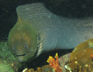
A giant moray comes out to say "Hi" to
Christopher, the photographer.
Destination Sri Lanka Letters Related Pages Sri Lanka HomeSL Flora & Fauna |
Heading for Sri Lanka
6 March 2007, 515 miles from Sri Lanka
 A giant moray comes out to say "Hi" to Christopher, the photographer. |
Dear Friends and Family,
We last left you in Thailand at the expensive Boat Lagoon Marina where we did a bunch of boat maintenance work (Cruising: doing boat maintenance in exotic locations). It was here that our "other daughter" Rachel left to return to her family and university in Australia. After 10 weeks of her delightful smile and fresh Aussie attitude, things were sort of quiet around Ocelot for a while.
Since our 1-month Thai visas had run out we headed back south to Langkawi on the Thai/Malay border. There we put Ocelot in the (much cheaper) Rebak Marina (6°18'N 99°42'E) and flew back to Thailand(!) for an 11-day land excursion.
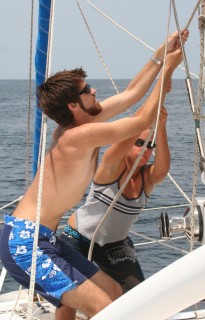
 Chris and Amanda haul up the mainsail. |
Once we returned to Ocelot we spent a few days catching up with friends and getting organized and on Feb 28 we headed 30nm NW to the Butang Islands (6°31'N 99°11'E). These are actually part of Thailand, but they're far enough offshore that the water's clear enough for diving. We chose a nice, remote area, picked up a convenient mooring, and were treated to a magnificent sunset against the lushly forested island while Amanda serenaded us on her guitar. In the morning we tried out our new Canon A710 Image Stabilized camera with its equally new underwater housing. Chris tested all the relevant features and decided he liked it, despite the long flash cycle time (due to only 2 AA batteries). He got some great underwater photos, our first since the Komodo/Rincha National Park of Indonesia 5 months ago.
On March first we jumped off for the 1,100nm passage to Galle, on the SW tip of Sri Lanka. Winds in the Andaman Sea were light so our first few days were quite slow and peaceful, just drifting along in the gentle breezes, but by March 3 we picked up a nice sailing breeze from the north and started scooting along.
Our course took us through the "Great Channel" between northern Sumatra (Indonesia) and the Nicobar Islands, which are actually part of India and controlled by the military, so not visitable. The Great Channel is a 25nm wide constriction in the marine highway that extends from the Mediterranean and the Middle East through the Malacca Straits, around Singapore, to the Far East. Huge ships were constantly in view. But we'd recently installed a new AIS receiver that lets us see these ships' transponders on our navigation program. We get name, position, course and speed, and it computes our closest point of approach (as well as a bunch of other info). This is magic for sailing in congested waters! If any ship will approach too closely (say, less than 2nm) we can call them (by name!) on the radio and ask them to change course, which most are happy to do.
At noon today we're at 6°18'N 89°11'E, or 515nm east of the southern tip of Sri Lanka (we crossed the half-way point last night). We have a 13 knot breeze from a bit aft of the beam, and a bit of assist from the current as well. We've had pods of Pantropical Spotted Dolphins playing in our bows several times. Ocelot's scooting along under all plain sail at 6+ knots and all is well on board.
Fair winds and calm seas -- Jon, Sue, Chris and Amanda Hacking
Top Level: Home | Destinations | Cruising Info | Underwater | Boat Guests | Ocelot | Sue | Jon | Amanda | Chris | Site Map | Make a Comment
|
If our information is useful, you can help by making a donation |
Copyright © 2000‑ Contact: Jon and Sue Hacking -- HackingFamily.com, svOcelot.com. All rights reserved.