 Click here to go back
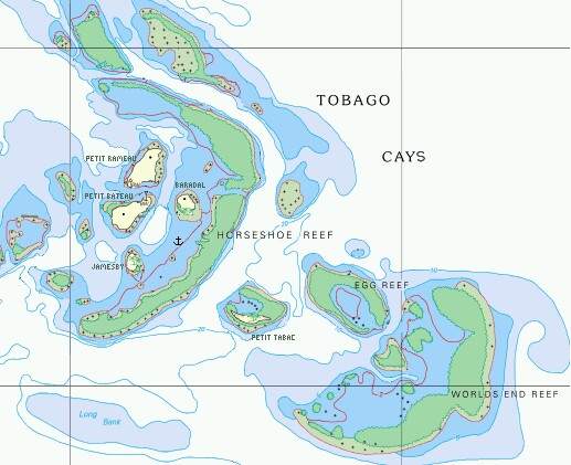
All of the times that we went to the Tobago Cays, we anchored in about the same place, between Baradal and Jamesby, inside Horseshoe Reef, in about 8' of water over clean white sand. The anchorage north of Baradal is OK if the winds are light, but it was always blowing 15‑20 knots while we were there. Most of the pictures taken looking down on the anchorage were taken from the top of Petit Bateau, the easternmost island.
Horseshoe Reef breaks the surface much of the time over most of its length. The best place through it is just east of the north end of Baradal, but even there one has to be careful because some coral heads stick up close to the surface, and new props for the outboard cost $200. There are dinghy moorings just outside the cut so we could snorkel the outside of the reef. We also took the dinghy to explore Petit Tabac, Egg Reef, and Worlds End Reef, but the best snorkeling we found was actually on each side of Horseshoe Reef.
Cruisers: We are now publishing Downloadable Track Files in OpenCPN (.gpx) format and in MaxSea (.ptf) format (not all tracks are available in all formats yet - we're still working on it and they take time). You can download the track files either by clicking on the links in the tables below, or by clicking on the track in the Google Map below the table. The MaxSea files are in native format but the OpenCPN files are zipped so they download faster, and they need unzipping after they've been downloaded (which most operating systems do natively). If 2 files are shown, the smaller one has been edited to remove redundant points from straight tracks. This improves the speed of the download as well as performance once the file is loaded. Sometimes MaxSea Track files are separated from the Mark (chart notations) files. Download instructions are provided if you need them.
These files are provided free and we are actively soliciting cruisers to send us your track files so we can post them for others to download. If you would like to to participate, please email us your track files (as attachments to our HackingFamily account, not our Winlink acct) along with your boat name and draft. If you include your website and boat details, we'll link back to you from our Cruising Links page.
Disclaimer: While we always try to provide useful information, we can take no responsibility for its accuracy or usefulness. Prudent mariners will always navigate using all means at their disposal, and will not rely solely on electronic navigation.
Southeast Caribbean Sailing Tracks
| Boat | Draft | Year | Comments | MaxSea | OpenCPN |
| Taniwani | 6.6' (2m) | 2005 | Grenadines | 12 KB | 6 KB |
Top Level: Home | Destinations | Cruising Info | Underwater | Boat Guests | Ocelot | Sue | Jon | Amanda | Chris | Site Map | Make a Comment
|
If our information is useful, you can help by making a donation |
Copyright © 2000‑ Contact: Jon and Sue Hacking -- HackingFamily.com, svOcelot.com. All rights reserved.