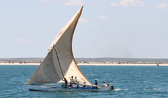
Madagascar sailing dhow
Mozambique Channel
9 November 2007, Bazaruto Bay, Mozambique
 Madagascar sailing dhow |
Dear Friends and Family,
We jumped off from Bali Bay, Madagascar (16°0'S 45°17'E) at 6am Saturday, November 3, with 2 other boats - Irene, a South African/German couple on a 38' (11.5m) Prout catamaran, and Kyena 2, a 33' (10m) monohull with an Australian/Indonesian couple and their adorable 1.5 year old daughter, all smiles and giggles. Bali Bay is about 50 nautical miles ENE of Cape St. Andre, which forms a nose about 85 nautical miles north of the westernmost point of Madagascar. Bali Bay is about the last decent anchorage along this coast and it's the traditional jumping off point for boats heading SW towards Mozambique and South Africa. The night before we left we all got together on Ocelot (of course) for a big potluck and strategy session.
Our strategy for the 1,000 nautical mile passage to Richards Bay, South Africa, was to head more towards the Mozambique side of the channel, as there we could pick up the beginnings of the swift Agulhas Current that sweeps down southern Africa. This would also let us duck into anchorages along the Mozambique coast if conditions warranted it.
We're no longer really in the trade winds, so we can't depend on the constant ESE winds that have pushed us 70% of the way around the world. The winds in the Mozambique Channel (between Mozambique and Madagascar) have usually been from the south, but like the Pacific, the winds here are determined by weather systems that move from west to east far south of us, down in the "Roaring 40s". A system was coming through that would bring strong winds from the NE, and we hoped to ride those winds down the Channel. The gotcha was that a front was forecast to come up the coast from South Africa, so it would be a bit of a race to see how far we could get down the Mozambique coast before the front smacked us.
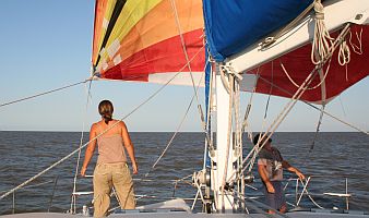 Jon and Amanda set the spinnaker |
Our sail the first day was delightful! We flew the spinnaker much of the day and then the wind moved more off the beam, giving us a fast ride. Since we were still near the coast, we were still in the onshore / offshore (morning / afternoon) winds that predominate along the coast of Madagascar. The wind died about 11pm and we started motor-sailing, which lasted much of the next day. This was expected if not hoped for - winds on the Madagascar side of the channel are often light, and the currents often contrary. We wanted to get out of the contrary currents as soon as possible.
The good news was that the forecast front looked like it would dissipate just a bit north of Maputo, Mozambique, so we could head more directly for Bazaruto Bay at 21°30'S 35°24'E or about 650 nautical miles southwest of where we started. This was a considerable relief as the next closer anchorages were far north of Bazaruto.
The winds eventually filled in from the NE at about 9:30pm, allowing us to shut down the engine. The wind slowly climbed to 25 knots, forcing us to take a reef in the main at 2am, always a bit more exciting than we like. But the strange thing was the current - it built up from 2 knots at 8pm to over 6 knots(!) by the morning of November 5th. The current was flowing basically SE, so it pushed us to the left quite quickly, forcing us to sail further to the west and even northwest to keep on our course. Eventually we were sailing at 290° just to make our course of 245° over the bottom. Crazy! We expected some current on this leg, but nothing like 6 knots. By afternoon the current began slackening slowly and flowing more to the south, allowing us to point more to the west and even a bit southwest.
But the big news happened that morning, Monday November 5th. Jon was on watch at about 6:30am when he suddenly saw, in a wave trough, what appeared to be a huge log floating just in front of us. He quickly disengaged the autopilot and wrenched the wheel hard to the right. Looking up, he recognized the "log" to be the back of a huge sleeping whale. But there wasn't enough time for Ocelot to turn as far as was needed. We came down (gently) on the whale with our port keel and then it dove, whacking us a good one with its tail back by the engine room as it did so.
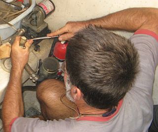 Jon repairing the engine-room bilge pump |
Checking for damage, we found that 4 hose fittings had broken in the engine room and water was coming in. The engine cooling water fittings were relatively easy to fix and that stopped the water from coming in, but the bilge pump fittings took a bit longer as some parts had to be adapted to fit. After an hour or so the water was pumped out and things were mostly back to normal. We also found that our outer skin of fiberglass was cracked over an area about 1' (30cm) on a side, about 1' (30cm) above the waterline. Our hulls are a sandwich construction - fiberglass, foam‑core, fiberglass - but only the outer skin of glass was broken. Luckily, the inside of the hull right there is heavily reinforced, so we still had hull integrity. But we didn't know how much damage we had below the waterline. Our keels are strong and the lowest part of Ocelot, but it's hard to imagine the whale didn't hit the left-side rudder and/or sail‑drive (propeller). We'd have to see when we got to Bazaruto.
That night was pretty rough - 30‑35 knot winds and building seas - but things calmed down considerably the next day. Both the wind and current eased, allowing us to turn off to a more comfortable point of sail. Ocelot loped along happily wing-and-wing with about 25 knots of wind directly behind us. We tucked 2 reefs in the main to starboard and the full jib out to port and let Otto (the autopilot) do all the hard work.
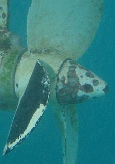 Bent blade on our port propeller |
Unfortunately, we were exactly the wrong distance from Bazaruto. We'd either have to race to get in before dark the next day, or stall and bob around for another night so we could approach the following day. We initially took what we thought was the prudent approach of waiting an extra night, but then we discovered 2 things: We heard that some inclement weather was approaching, and we found that we were finally in the swiftly flowing Agulhas Current and it was adding almost 3 knots to our speed. So we put the pedal to the metal and shook out the reefs, covering over 100 nautical miles in our final 12 hours and averaging about 9 knots, despite weakening winds all day.
Our final challenge was that we arrived at the entrance to Bazaruto Bay at full ebb tide, so this brought the current against us. The outer anchorages would not have been protected with the prevailing easterly winds, so we had to go 9 miles inside the bay, with a 2 knot current against us, to anchor. We arrived about 10 minutes before absolute dark and anchored in 27' (9m) at 21°37'S 35°20'E, behind Santa Carolina (Paradise) Island. Our final passage stats are 689 nautical miles sailed in 4 days 13 hours for an average of 6.3 knots. Long hot showers, a delightful dinner, and a mindless James Bond flick to decompress before we all crashed in wonderful slumber. We didn't even have to hold the beds down to keep them from rocking!
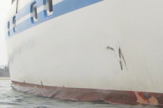 Whale damage to our hull, ~1' or 30cm across |
The next morning we dove on Ocelot to see if we had additional damage. The whale's tail appears to have whacked both our prop and our rudder on port side, bending a blade on our (new!) prop and taking a small chunk out of the bottom of the rudder. The propeller is easy to replace - we now carry 5 spares - so we quickly put on one of our folding propellers. The rudder also shouldn't be very difficult as they drop down out of the boat fairly easily. This will allow us to do a proper epoxy fix on dry land.
We'll probably stay in this area for the next few days. Our friends on Irene and Kyena 2, who left the same time we did, arrived 40 hours after us and had to weather a nasty 40 knot southerly squall (which had us scurrying around to the other side of Paradise Island in the middle of the night). We'll probably go do some exploring until our next weather window lets us hop south. We have 2 more potential anchorages on our way to Richards Bay, 500 nautical miles away - Inhambane, 130 nautical miles south of us and Inhaka just offshore of Maputo, 240 nautical miles past that. We may bypass 1 or both if conditions permit.
Fair winds and calm seas -- Jon, Sue and Amanda Hacking
Top Level: Home | Destinations | Cruising Info | Underwater | Boat Guests | Ocelot | Sue | Jon | Amanda | Chris | Site Map | Make a Comment
|
If our information is useful, you can help by making a donation |
Copyright © 2000‑ Contact: Jon and Sue Hacking -- HackingFamily.com, svOcelot.com. All rights reserved.